
Water Closet for September 19, 2014
“Why is the land so up and down”, the boy asked his grandpa who year round, almost daily, roams the undeveloped forests and fields of Middleton and beyond, especially along its streams and river.
[pullquote]” It obviously wasn’t man who left the massive rock from somewhere to the northwest.”[/pullquote] “Because of the glaciers here long ago”. , said grandpa, who while old, had missed the last continental glacier by 10,000 years. It was a good question and he knew that he would have to try to explain the existence of great ice sheets he had never seen. Even the geologists, who finally figured out the origin of the many signs of continent sized masses of moving ice, had seen only mountain glaciers and their leavings and remnants of continental glaciers covering Antarctic and Greenland. From the many signs of their passing and melting, clues that had so long had eluded others, they concluded that there had been great thick sheets of ice moving rocks and whole hills around. Many of the ups and downs and sediment deposits were soon explained. Within less than half a century geologists had mapped the edges of the last ice sheet called the Wisconsin. All of the northern part of what is now America and its mountain chains tending south were covered. In some places the ice was a mile or more deep, estimates for here are about one-half mile. In expanding out of mountain ranges to the north it gouged, dug, toppled, plowed, picked up, sanded, polished, and plucked the bedrocks and soils beneath. Massive amounts of boulders, gravels, sands, silts and clays joined the moving ice. These debris laden ice masses deeply abraded ledge and other landforms encountered. On melting they left their loads behind and with melt water hydraulically carved out rivers and valleys.
The expansion and retreat of the Wisconsin Glacier took tens of thousands of years. Grandpa reviewed all he’d read about this since a boy and then thought of ways to explain to his questioner. What he had just gone over in his mind in seconds had taken him, even after being told, decades to appreciate.
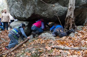
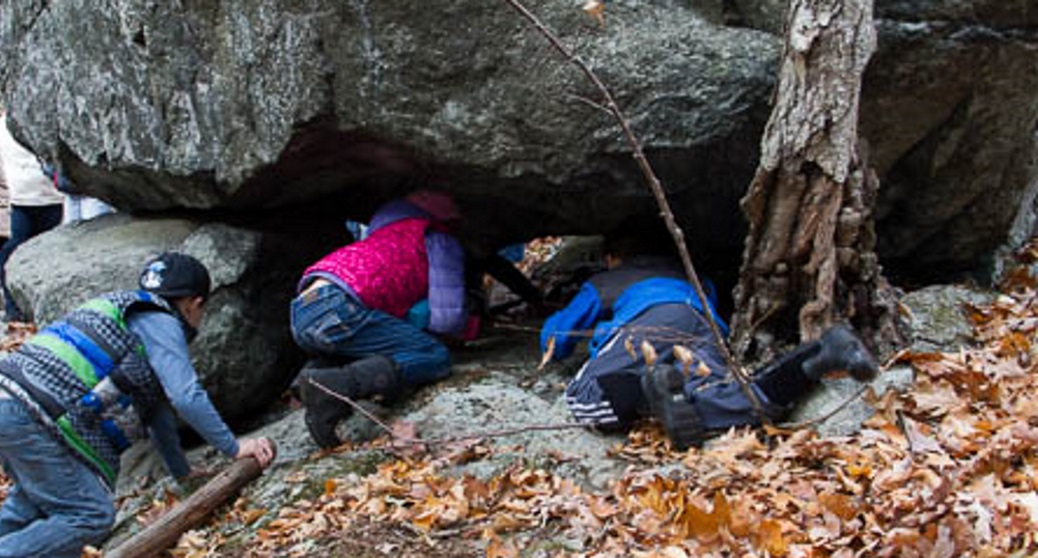
Indian children had probably been exploring the opening under this glacial erratic for ten millennia before the modern youngsters seen here.
– Judy Schneider photo
Thousands with far better minds had spent centuries pondering the great boulders scattered around, the round deep ponds called kettles, the serpentine knolls of gravel called eskers, the scratches and gouges in hard granite, the oval hills with long axes NW to SE dubbed drumlins, the boulder trains tending in the same direction down from high ledge, and the numerous U-shaped valleys aligned with the moving ice. Scores of these signs of expanding and receding ice are found in Middleton alone; millions if we count the large rocks left behind on melting. It took grandpa decades of reading and wandering among the evidence to somewhat understand the whole. He’d have to answer the boy in steps upon encountering signs over time. Alas, quick boys and girls don’t want long answers.
The gauntlet thrown, the old hiker had to accept the challenge and try. The boy’s questions about the glacier-sculpted features were asked again the other day by fellow old timers on a Friday morning hike on Middleton’s trail called the Anne’s Land Loop. Actually the questions weren’t asked so much as anticipated and answered upon coming across signs. Once people have accepted the past existence of continental glaciers it is a lot easier to explain. The dozen walkers had learned of them mid last century in grammar school. They may not have become familiar with all the evidence in the field so the hike leader felt obligated to explain.
We’ll offer a massive example as evidence. It is one the walkers always stop at on the Anne’s Land Loop. In the most pleasant of pre-fall mornings with almost all the leaves still green we climbed a forested ledge and marveled at what the geologists call a glacial erratic.
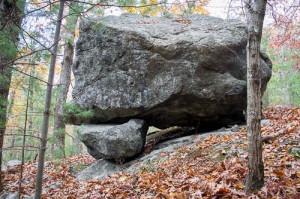
This room sized stone in Middleton left by the last continental glacier is called an erratic even though it has been sedentary over 10,000 years.
– Judy Schneider photo
The great boulder the size of a room is perched on the ledge on two points. Ledge and boulder granites are completely unconnected. The boulder, far from man’s activities except for past pasture and hunting grounds, could not have been moved there by even a score of oxen. It obviously wasn’t man who left the massive rock from somewhere to the northwest. It had to have been carried by the ice which later melted and let it down upon the ground. Early wonderers had ready answers not requiring thought. Noah’s flood had rolled it there or God had simply placed it so. Many early observers must have doubted this as the origins of erratics but kept their mouths shut. A great hue and cry was raised by the faithful when Harvard’s revered naturalist Louis Agassiz with others help came up with the theory of continental glaciers in the mid 1800s. Charles Darwin shook things up even more a few years later with his book On the Origin of the Species. Agassiz, strangely to us over a century later, didn’t accept Darwin’s theory of Natural Selection explaining evolution.
No hue and cry from us thanks to Agassiz and enlightened geologists who followed as we sat in the erratic’s shade and pondered again the boulder’s origin perhaps far to the northwest. One old Closeteer, a frequent visitor to this favorite spot deep in woods protected by Greenbelt, always thinks of Indian and later Colonial children playing in the ample space under the rock. It must also have long served as temporary shelter for bears, wolves and lesser mammals. To the Closeteer on lone visits, the presence of little Algonquian speaking children is almost palpable. They were here all right; they couldn’t have resisted climbing under and over the great stone.
The Friday hikers moved slowly on, undulating over the ups and downs of mini-U-shaped valleys draining southeast flanked by slopes of resistant ledge. The slow growing oaks above filtered the lovely September light. Just 60 years ago, judging from the trees’ ages, this was poor rocky pasture. Eyes were out for further signs of the unseen presence that had shaped the land, the half-mile thick ice sheet whose bottom was under enormous pressure in coming, and spewing melt water from its front while going.
Note: Favorite geology books in the Water Closet, our movable shack you’ll never find along the river, are Roadside Geology of Massachusetts by James W. Skehan (Mountain Press Publishing Company, Missoula, Montana, 2001) and The Physical Geography, Geology. Mineralogy and Paleontology of Essex County, Massachusetts by John Henry Sears (The Essex Institute, Salem, 1905). Sears tome has over 200 snapshots of Essex County topography. It gives us a valuable look at our once largely open land now covered with trees. Skehan has a good section on glaciation in the north east.
_____________________________________________________________________
WATER RESOURCE AND CONSERVATION INFORMATION
FOR MIDDLETON, BOXFORD AND TOPSFIELD
| Precipitation Data* for Month of: | June | July | Aug | Sept | |
| 30 Year Normal (1981 – 2010) Inches | 3.95 | 3.89 | 3.37 | 3.77 | |
| 2013 – 14 Central Watershed Actual | 2.03 | 7.26 | 2.20 | 1.5 as of 9/12* | |
Ipswich R. Flow Rate(S. Middleton USGS Gage) in Cubic Feet/ Second (CFS):
For Sept 12, 2014 Normal . . . 5.2 CFS Current Rate . . . 30 CFS
*Danvers Water Filtration Plant, Lake Street, Middleton is the source for actual precipitation data thru Sept. Normalsdata is from the National Climatic Data Center.
THE WATER CLOSET is provided by the Middleton Stream Team: www.middletonstreamteam.org or <MSTMiddletonMA@gmail.com> or (978) 777-4584