
Water Closet for December 15, 2017
[pullquote]” The cows, cats, and Artie’s horse are long gone. Wildlife is thriving. The native artifacts and mounds are still there but are overgrown and not easily found” [/pullquote] A few days ago the old Closeteer returned to a favorite part of his world. As a child it was the only part of the world! He took a dear friend from Salisbury with him to look for spots remembered. She lives on Rings Island across the river from Newburyport whose ships once sailed the seas from Canton to Liverpool and most places in between. The Closeteer grew up on a farm just north of Rings Island on Ferry Road given that name because it went to and from the ferry before the first bridge across the Merrimack River.
He and his friend found that the once farm fields all along much of Ferry Road are now supporting houses and trees. From Ferry Road they turned east on Sweet Apple Tree Lane where three-quarters century ago old Baldwin apple trees still grew along with hayfields and pastures. Baldwin apples were once a favorite for winter storage and export to England.
The Closeteer’s childhood playground increased in area each year. Red maple swamps where cord wood was cut, blueberry patches around pastures, cultivated fields of sandy soil, and salt marsh laced with meandering cricks spread out to him all within a twenty-minute hike from a great river emptying into the Atlantic between barrier beaches off Salisbury and Plum Island, the once shifting, treacherous gates to the Merrimack River. Much of the Merrimack’s water descends over a hundred miles from the White Mountains of New Hampshire. The Closeteer has long loved knowing the estuary had been the summer agricultural lands and playgrounds of 150 generations of people who before Columbus did not call themselves Indians.
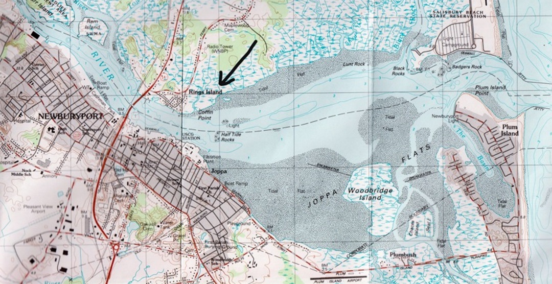
Mouth of the mighty Merrimack River where it enters the Atlantic between the barrier beaches of Salisbury and Plum Island. Natives played, fished, dug clams, hunted, and grew corn, beans and squash here each summer for millennia before the English. – USGS map, Newburyport quadrangle
Sweet Apple Tree Lane leads to Massachusetts Fish and Wildlife Managed Lands where the natives left many signs. One is a thirty or so foot diameter circle of large stones, quite unlike an English wall, now somewhere in an overgrown field he knew as Hatch’s hayfield. The rumor around town was that it had been a native grave site for their smallpox victims. Boys and girls in passing to the salt marsh skirted it and wondered. The old visitors’ other destination was a symmetrical mound of sand, ten feet high, 200-feet in diameter. As a boy in the 1940s he and a friend dug into it looking for arrowheads. Using a screened sifting-box they found many clamshells but only one point, a beautiful spearhead of white stone. The arrowheads they usually found in fallow fields nearby were small bird points, small triangles of black flint. Had the boys gone deeper they’d have found skeletons stained with rusty-red hematite.
The visitors passed where he thought these places were and without stopping proceeded down the lane which ends on a peninsula of upland projecting out between salt marshes to the river. When the Closeteer was a boy the abandoned pasture there was going over to bushes and trees. The peninsula’s end is punctuated by a 12-foot high rough cone of ledge, base diameter 50-feet, called Morrill’s Rock on the edge of the river. The Closeteer, his sisters, friends, and surely generations of other children found it a favorite spot to play. It has depressions to hide in from the wind. At high tide they sometimes swam around its river edge. Wide clam flats stretch out from it at low tide to the river channel. Older returnees just sit on the top of Morrill’s Rock to watch wildlife on the flats, marsh, and air above and boats passing while remembering days gone by. The couple last week sat in crevices and stood on its peak. The woman, her house one of two score houses on a ten thousand-times larger knoll of granite a mile up river called Rings Island, was regaled with memories from his boyhood. We all had such retreats before the world caught us up. She knew Morrill’s Rock as seen from the river when she’d rowed past dozens of times in Rings Island Rowing Club dories. Their dory days have largely passed; now they paddle a canoe on smaller rivers like the Ipswich and Parker.
They left the river and returned rising through cedars, then patches of hickories and black locust he knew as bushes when a boy. They passed the site of Doctor Wheeler and his family’s house. The state had torn the house of its benefactor down after taking over the land he gave them for conservation and open space. Also gone were the half-burned house of Artie Dow and the small house of Peg Leg Marshall, interesting characters who lived near Doc Wheeler at the end of Sweet Apple Tree Lane. Peg Leg was an old mason with a wooden leg. Artie had a horse and wagon he used to carry fish scraps to a nearby field for dozens of feral cats.
The cows, cats, and Artie’s horse are long gone. Wildlife is thriving. The native artifacts and mounds are still there but are overgrown and not easily found. As the visitors returned to their car a friendly man came down the driveway from a handsome new house built between where Artie’s and Peg Leg’s had been. We told Steve Battle what we were doing and found him immediately interested. He invited us into his house to meet his wife Patricia. He showed us a monograph describing the archeological work at Sweet Apple Tree Lane in the 1970s as we looked easterly through the Battles’ large windows across the marsh and river to the beaches and ocean beyond. In a glance we were seeing what the natives from upriver came for each spring. It had been their playground and agricultural land too. After more reading and questioning amateur Salisbury historian Wayne David, who the Closeteer knew as a boy, the visitors will return and bring Viet Nam veteran Battle with them to find out more about the people who enjoyed the place for thousands of years. Wayne says the digs he helped with have charcoal, bones and artifacts that go back seven millennia. The four assembled at Battles’ windows couldn’t see the people here before the English but somehow felt they weren’t alone. The old Closeteer as a boy had often felt that way. In mid-life he wrote:
LOOKING FOR ARROWHEADS
We often did this fallow field
Eyes in competition down
Sharp out for glint of flint
A chip, a flake, a sign
Or perhaps the product still intact
We’d found there before.
Every time in passing by
Hope rose anew and held us
To our random downcast wander
Perhaps just to be there was enough
Salt hay smells joined those of the woods
Across the marsh the river shone
Always beckoning to us boys.
After the rains we sought again
Surface rocks stood in relief
Each must be checked for telltale marks.
I still look down in kindred fields
Without a hope of much to find
But out of habit of another time
When cool spring soil met naked feet
My full attention on its skin,
Seeking signs from those before.
__________________________________________________________
WATER RESOURCE AND CONSERVATION INFORMATION
FOR MIDDLETON, BOXFORD AND TOPSFIELD
| Precipitation Data* for Month of: | Sept | Oct | Nov | Dec | |
| 30 Year Normal (1981 – 2010) Inches | 3.77 | 4.44 | 4.55 | 4.12 | |
| 2017 Central Watershed Actual | 2.44 | 4.03 | 2.6 | 0.9 | |
Ipswich R. Flow Rate (S. Middleton USGS Gage) in Cubic Feet/ Second (CFS):
For Dec 9, 2017 Normal . . . 59 CFS Current Rate . . .15.4 CFS
—————————————————————–
*Danvers Water Filtration Plant, Lake Street, Middleton is the source for actual precipitation data thru Oct.
** Middleton Stream Team is the source of actual precipitation data for Nov and Dec.
Normals data is from the National Climatic Data Center.
THE WATER CLOSET is provided by the Middleton Stream Team: www.middletonstreamteam.org or <MSTMiddletonMA@gmail.com>
rtp 800 hello my website is rtp 800
finemec hello my website is finemec
sapiens hello my website is sapiens
mr nice hello my website is mr nice
helene hello my website is helene
gustilo hello my website is gustilo
js加密 hello my website is js加密