
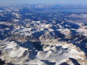
Sierra Nevada, California’s great water catcher and reservoir in the sky –
Internet photo
Water Closet for 1-31-14
Sad news of California’s long drought was featured in the media last week. That corner of the nation diagonally opposite New England, three thousand miles across country and continent, is in serious trouble due to low precipitation. New England averages about 50 inches per year overall to California’s 10 to 100 depending on where you are. In the past year only about 20% of that has fallen there. Ranchers are now selling cattle and horses due to a lack of grass. Hay prices have skyrocketed. Vast areas of crop land lies fallow. On hearing this grim news in the Water Closet, Stream Teamers have had lively discussions about the diverse beauty of California, a state with over twice the area of New England and two and one half times more humans. Several of us have been to that wondrous land of high mountains, deserts, valleys with rich soils, foggy redwood forests, spectacular coasts with open and forested hills descending to the Pacific, long beaches punctuated by rocky knolls, vineyards, and large cities with Spanish names. Moisture laden air flows in off the Pacific after being cooled by the south flowing California Current causing the vapor to condense as fog, which is then combed by trees rising to the skies. Moving on east the remainder passes over warm valleys where the fog reverts to vapor and clouds. After passing over broad agricultural areas, it climbs foothills and then the Sierra Nevada range where cooled and converted to fall as rain or snow. In the winter deep snow packs form thus storing the blessed water until melting releases it to return where needed in gardens and cities. This winter the pack is thin. The people down below so dependent on water from the two-mile-high-plus wall of mountains1 running north-south three fourths a thousand miles worry. If the water doesn’t accumulate in the beautiful storehouse in the sky there will be fires, empty rivers and aqueducts, strict conservation measures, and poor crops. Governor Jerry Brown now is strongly urging conservation. Soon, if the atmospheric high lingering uncharacteristically along the coast doesn’t move on, he will take more drastic action. The high pressure barrier is shunting storms to the north around his state. One old Closeteer often remembers a visit with wife to the ancient bristle cone pines in the rain shadow east of the Sierra Nevada on the Nevada-California line. On that side of the range the mountains rise abruptly. The mighty peaks covered with deep snow sparkle in the sun. They seemed an endless glistening white wall of thunderheads in their majesty. The 19th century pioneers from the east knew through their guides that beyond them was the Promised Land. After months of desert travel that must have pulled them on, too much so in the case of the ill fated Donner Party that froze. The “Okies”, escaping the Dust Bowl of the Midwest, came later spurred on by stories of a land of milk and honey. Traveling on a route south of the Sierras through the Mohave Desert, they arrived in rickety trucks and cars. Their problems arose anew upon arrival in the Central Valley of the Golden State2, an expected Eden. They weren’t greeted kindly; the bias against these refugees from the Dust Bowl lingered on too long. Now the dreamed of irrigated Eden is in danger of becoming a dust bowl. Pumps have lowered water tables. The usual snowmelt down from Sierras may be lacking. Thoughts of the great state have us reviewing its geography. California is roughly the area of Old and New England combined. In the south is a desert2 almost twice the size of Maine. The fertile Great Valley has twice the area of Massachusetts flattened out. The redwood forests between the coast and northern valleys sometimes get 100 inches of rain per year. Not this year! California’s largest trees are three times the height of our tallest. Is it any wonder the great naturalist John Muir settled there and spent much of his life describing its marvels in prose bordering on poetry? His influence on President Theodore Roosevelt is thought to have resulted in the protection of many tens of thousands of square miles there and around the country.3 Now Muir’s heaven is threatened again, this time not by earthquakes, but by changing climate. This present drought may be the worst since 1896. There were terrible droughts in the 1970s. Let us hope the high pressure wall will move on east and allow the water in. In the meantime, maybe Californians will teach us all lessons in water conservation. They did late last century with air pollution. One old Closeteer who worked in Santa Monica in the summer of 1956 can still almost feel the headaches he experienced some afternoons in the Los Angeles Basin as the day’s smog from traffic accumulated. Strict pollution controls have alleviated much of this manmade plague. Now let’s hope California will solve its water problems. 1 North to south – Klamath Mountains, Cascade Range, Sierra Nevada 2 What an awful nickname “Golden” is for a state with so much natural beauty other than that of an element destructively torn from the ground. It wasn’t only the land that was desecrated but the habitats of native peoples. There were 21 or more tribes of Indians in California for several thousand years before the Spanish, Mexicans, and Americans. All are gone. Many were murdered by the miners and other immigrants for sport. By chance as this essay was being written a friend loaned us Ishi in Two Worlds a much praised book by Theodora Kroeber. It is about the last member of a last Californian tribe. 3 Mohave Desert 4 We recommend Douglas Brinkley’s 2009 book The Wilderness Warrior about Theodore Roosevelt’s successful accomplishments in the areas of land protection and conservation.
WATER RESOURCE AND CONSERVATION INFORMATION
FOR MIDDLETON, BOXFORD AND TOPSFIELD
| Precipitation Data* for Month of: | Oct | Nov | Dec | Jan | |
| 30 Year Normal (1981 – 2010) Inches | 4.40 | 4.55 | 4.12 | 3.40 | |
| 2013 – 14 Central Watershed Actual | 1.10 | 3.35 | 5.30 | 4.40 as of 1/28** | |
Ipswich R. Flow Rate (S. Middleton USGS Gage) in Cubic Feet/ Second (CFS): For Jan 28, 2014: Normal . . . 66 CFS Current Rate . . . 54 CFS —————————————————————————————————– *Danvers Water Filtration Plant, Lake Street, Middleton is the source for actual precipitation data thru Dec. Normals data is from the National Climatic Data Center. **Updated Jan precipitation data is from MST gage. THE WATER CLOSET is provided by the Middleton Stream Team: www.middletonstreamteam.org or <MSTMiddletonMA@gmail.com> or (978) 777-4584
What is the environmental benefit of flooding “Death Valley” with Pacific Ocean water…one inflo pipe and one outflow pipe to reduce escess salinity?
This pilot program might induce other desert areas on the planet to do the same which would offset the longer effects of rising oceans coupled with the production of more rainwater for agricultural and general water needs.
Just a thought……