
Water Closet for May 9, 2014
Almost two centuries of railroads have changed our continent and the world. In America internal combustion engines on paved roads have largely passed them by. In eastern Massachusetts the web of rail beds now lie relatively silent beneath the soft feet of hikers, wildlife, and bicycle tires.

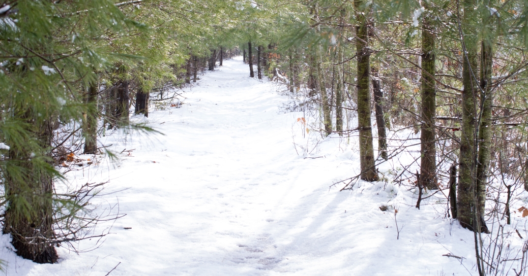
From Mother Nature’s rail-trail art gallery: “Swirling Dance of Ice and Air”
Pamela Hartman photo
In neighboring Topsfield, Wenham, Danvers, and Peabody the old beds once supporting ties, rails, and heavy steam engines have been smoothed and surfaced with asphalt or stone dust. People of all ages flock to them for exercise and to escape from car filled roads. [pullquote]”In winter the tracks of fisher, otter, beaver, skunk, squirrel, mice, deer, and coyotes decorate the snow.”[/pullquote]A Boxford committee has long been working on plans to add to the Topsfield path on the old Boston and Maine line. The larger plan is to continue on through Georgetown and connect to trails in Newburyport and Salisbury and who knows how much further north. In Middleton the once active line from Lawrence to Salem, 1848 to 1926, curves southeasterly for five miles through three watersheds. Railroad engineers try to avoid curves and grades. To reduce the latter they followed rivers and streams.
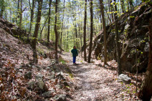
Rachel Schneider hiking through granite canyon cut circa 1848 between Boston Brook and Emerson Brook, watersheds Essex Rail Way.
Judy Schneider photo
They used to build right through wetlands when that was allowed. Our favorite parts of rail-to-trail paths are along wetlands where the wildlife hang out. Some Middletonites and friends1 often hike from North Andover south to the Ipswich River and beyond into Danvers on the old Essex Rail Way line. Middleton Rail to Trail Advisory Committee1 has been working since its formation two years ago on plans to smooth it up, thus making it open and attractive for all.
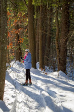
Stream Teamer Glenice Kelley snow-shoeing on the trail where trains once reigned. White pines have taken over this northern Middleton section of the rail-road bed.
Judy Schneider photo
Before telling you of the committee’s article on next week’s town warrant, let’s take an imagined hike together from Sharpners Pond Road, on the North Andover-Middleton line, to Hathorne in west Danvers. On Sharpners Pond Road is a sign that invites hikers to step off on to the Essex Rail Trail near where Boston Brook flows south under the road. On its bed, elevation about 90 feet above sea level, we find ourselves in mature woods flanked by wetlands in the floodplain of Boston Brook. The floodplain was taken over by beavers around the turn of the millennium. They drowned the red maples with their dams across the brook; lovely diverse open “beaver meadows” have developed where once there was shade year around. This rich wet habitat along the rail line continues almost straight south along Boston Brook which crosses twice across its bed thus shifting the channel from side to side. The water is descending very slowly as are us walkers. By the time we get to the Ipswich River at elevation about 40 feet we’ll have dropped only 50 feet in three and one-half miles. The engineers carefully chose this flat route to avoid fuel-consuming grades. Old timers on foot appreciate this a century and one-half later. So will little kids on bicycles and mothers pushing carriages once the trail is smoothed and paved. The wonderful parts of such rail trails are the seasonable changes in the wild woodlands and swamp gardens off to the sides. The birds change week to week as do the stages of blossoming plants. In winter the tracks of fisher, otter, beaver, skunk, squirrel, mice, deer, and coyotes decorate the snow. After about two miles Boston Brook abruptly turns east away from the railroad bed which continues on SSE over a divide from the Boston Brook watershed into the Emerson Brook watershed. Here the railroad contractors had to cut a notch through a few hundred yards of granite ledge using black powder. A few drill holes for the explosive can be seen in the mini-canyon walls. Dynamite came later. The cut stone was used for fill and retaining walls elsewhere along the line. It took lots of fill from nearby pits to fill the wetlands just passed. As we drop very gently into the Emerson Brook watershed the line takes a gradual curve southeasterly following the brook’s floodplain. On crossing Essex Street again we are graced for a while by a great beaver meadow where wildlife abounds. Another cut through upland soon greets us with a mature oak forest to the north and a string of vernal pools between the rail bed and upland to the south. We can hear the traffic on parallel Route 114 out of Middleton Square but can’t see it. Just below Middleton Square almost in the afternoon shadow of Howe Manning School we pass over where the Central Street Station and half-round-house were actively in use until the last trains in 1926. The station is now a house. On eastward we continue through partially developed land. Even with summer foliage houses can be seen along portions of both forested sides of the bed. It is still very pleasant and lively due to wet swales on both sides. We continue in shade as we pass in back of the Old Town Hall and Tramp House on Maple Street. Behind the Congregational Church we climb over Webb Street which once had a bridge that was replaced with a blocking causeway. Soon we near the bed’s convergence with Maple Street and descend into the Ipswich River floodplain. Here future hikers on the planned rail trail will have to stop and cross carefully. No doubt a light is planned. However, the first phase of the trail project will end here at Maple Street 1.4 miles from its start where Essex Street crosses Emerson Brook.

Morning after a storm, the rail-trail is still without tracks. Off to the sides and below the flanking white pines are wetlands, home to diverse wildlife.
Judy Schneider photo
Finally we reach the Ipswich River, recipient of flow from the Boston and Emerson watersheds. These tributaries converge with their river about a mile down stream. At Mortalo Landing across the street from where the rail road bridge once was, we enjoy a rest and snack on the great stone steps of a Vito Mortalo built canoe-kayak landing.2 Vito’s riverside bottom stair is at the lowest elevation of our journey. However, spirits are high; the water passing beneath us comes all the way from Wilmington and beyond and will join the Atlantic at Plum Island. Here in our small town is our watery connection to the world. After recrossing Maple Street and then the river we are back on the railroad bed heading east by what were once the best farm lands in the area. There was stop here called Howes Station.
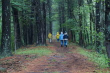
Hikers walk away down rail-trail where once steam engines filled the then treeless air with sound and at times smoke and soot. Judy Schneider photo
These fields may have been cultivated for 3000 years up until about the early 1600s by the Indians and since then by Englishmen and later other Old Worlders who share more of our DNA. In the late 19th and early 20th century the Gregory Seed Company planted hundreds of acres near the line not far from the river. Danvers State Hospital patients farmed much of the rest of the land up until mid last century. Richardson Farms still grows corn, alfalfa and cover crops on the land owned by the state. In this stretch we get a good view of the same open fields the train passengers enjoyed. The hospital patients and Gregory’s workers have been replaced by machines. We still see a few people tending their patches with hoes on the south sloping Community Garden. Soon Essex Aggie buildings are to our north and at last we are beneath Hathorne Hill, for a century the home of Danvers State Hospital. We finish our hike at the sad steep uphill stairs where patients, many never to return, walked up from the hospital railroad stop with kin and perhaps a greeting nurse.

Spring time on the rail-trail between Essex and Howe Manning School. This is a western section of Phase I to be voted on at Town Meeting. – Derek Fullerton photo
Let’s leave that sad note and return to the happy rail to trail plan. The late Rex Trailer ended his popular children’s TV program with “Happy Trails”. Contemporaries of Rex, singers Roy Rogers and Dale Evans, had a hit entitled “Happy Trails to You”. Middleton’s neighbors to the northeast, east and southeast have already acted perhaps subconsciously inspired by Rex, Roy, and Dale, now it is Middleton’s turn. The warrant article below is for Phase I of III in which the Middleton committee wants to construct a 1.4 mile section of the rail trail from Maple Street to Essex Street. This section will abut the Howe Manning School and link to the nearby center of town with its fine library. In the Middleton May 13 Town Meeting Warrant, article 6 reads as follows: On petition of the Middleton Rails to Trails Committee and Board of Selectmen to see if the Town will vote to raise and appropriate $130,000 to construct Phase 1 of the planned 5.2 mile Rails to Trails pedestrian and bike paved trail way including but not limited to parking areas along the utility and former “narrow gauge” right of way from Maple Street to Essex Street a distance of approximately 7000 feet, and to authorize the Town to apply for grant funds through the State Department of Conservation and Recreation and to see if such funds will be raised by taxation; by transfer of available funds, by borrowing or by any combination there of. The Middleton Stream Team and the Middleton Council on Aging/Conservation Commission Friday Morning Hikers urge all Middletonites to attend town meeting next Tuesday to vote on this article.
1 The Middleton Rail Trail Advisory Committee was formed by the 2012 Town Meeting. Derek Fullerton, Director Public Health and co-author of “Hiking for Health and History”, Middleton’s hiking trails book, spearheaded its formation and is now vice chairman. Scott Cameron is chairman, other members are Frank Twiss, Rodney Pendleton, Thomas Martinuk, Hector Quarti, Scott Downs, Brad Swanson – ex officio, Katrina O’Leary, John Stanwood – business rep. of Woody’s Cyclery.
2 Middletonite Vito Mortalo, raised in Rome among ancient structures, has given us three fine stone landings of his own design on the Ipswich River. The Stream Team urges you to visit them at South Main Street (Route 114), Maple Street (Route 62), and Peabody Street. ________________________________________________________________
WATER RESOURCE AND CONSERVATION INFORMATION FOR MIDDLETON, BOXFORD AND TOPSFIELD
| Precipitation Data* for Month of: | Feb | March | April | May | |
| 30 Year Normal (1981 – 2010) Inches | 3.25 | 4.65 | 4.53 | 4.06 | |
| 2013 – 14 Central Watershed Actual | 4.34 | 4.32 | 2.86 | 0.1 as of 5/6** | |
Ipswich R. Flow Rate(S. Middleton USGS Gage) in Cubic Feet/ Second (CFS): For May 6, 2014: Normal . . . 80 CFS Current Rate . . . 103 CFS *Danvers Water Filtration Plant, Lake Street, Middleton is the source for actual precipitation data thru April. Normalsdata is from the National Climatic Data Center. **Updated May precipitation data is from MST gage.. THE WATER CLOSET is provided by the Middleton Stream Team: www.middletonstreamteam.org or <MSTMiddletonMA@gmail.com> or (978) 777-4584
it’s nice to see the old railroad beds saved and used as trails, rather than built upon or just bulldozed. We have photos of trains at many of the locations you mention above. Sometimes, even now, you may find an old track spike or a tie plate sticking out of the ground. Granite bridge abutments stand at the edges of brooks. There’s even an old coal unloading trestle next to the power house at the site of Danvers State Hospital at Hathorne, The Middleton depot still stands and is a house. It was turned 90 degrees and moved to the adjacent road opposite the electric company’s transformers, etc. The old trolley car “flyover” just off Rte. 62 was intact until a few years ago when it was taken down for its granite blocks. The depot at “Howes” is still standing as a much remodeled home up on East Street near the Rte. 62 intersection. And of course the Danvers Depot (last remaining of what once were 9 stations in town) still stands at the Townsend Fuel Co. off Hobart Street. It was given to the town, but they were not able to locate a new site for it, and its future is precarious at best. It likely will not be saved, mostly due to apathy. Bedford, Mass. has saved their depot and made it part of the famous Minuteman Bikeway. Danvers could do likewise.