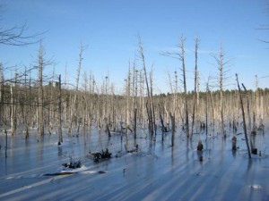
- Beaver impoundment and heron rookery in northern tip of Middleton. Herons’s nests are seen high in dead white pines. The shadows on the ice are those of drowned white cedars.
Stream Team photo
Water Closet for 1-3-14 Pond Meadow
The Pond Meadow Pond beaver impoundment and heron rookery in north Middleton near where the three human towns of North Andover, Boxford and Middleton meet was visited last week on ice before the warm ice-eroding rain between Christmas and New Years Day. The beavers have made it a special place often visited for real and here in print in the Water Closet. Just 14 years ago in 1999, while at the same latitude and longitude, it was a very different place.
Imagine a shallow lumpy wide-edged plate made by the last continental glacier not an amateur potter. The bottom 150 plus acres is flat. In the surrounding broad sloping rim are several grooves. Water runoff from the uplands enters some. The water collected in the basin exits south in another. Technically under the Wetland Protection Act these are called intermittent and perennial streams. The beavers in 1999 dammed the exiting perennial stream called “Pond Meadow Brook” by the Stream Teamers. The extensive wooded uplands around the once red maple swamp, now beaver impoundment, are without houses, paved roads, fields, and people thanks to Richardson Farms, Boxford State Forest and Greenbelt. On our dozen or so yearly visits we rarely encounter other members of our species. Sometimes the tracks of hunters are seen in the fall intertwining with those of deer, fisher, coyote, squirrel, mice, otter, and small birds. The track makers are rarely seen, just signs telling us we are not alone.
The old Closeteer on his visit the cold afternoon before Christmas Day found ideal conditions. The ice on the impoundment due to a cold December was four to five inches thick and safe over much of the vast flooded area. Doubtful patches were easily spotted and avoided. Because of a relatively dry late summer and early fall the water level in the impoundment was down a couple of feet below the top of the 200-foot long beaver dam. Three lodges well up from the dam appear to loom much higher because of the lower water. Most winters, water would be trickling over the top of the dam. For a decade now the swamp trees, red maple, Atlantic white cedar and a few large white pines have been dead without buds, leaves, and now even bark. Most of the dead maple trunks have fallen and are decaying in mud beneath the ice. The decay resistant cedar trunks, adorned with tough branches, still stand straight. Only a few are down. The Closeteer likes to hike on the ice between their gray corpses in thick cedar stands that before death and loss of evergreen tops blotted out much sunlight even in mid day. He has cut down several dead Atlantic white cedars around town to count their annual rings. Small trees six to eight inches in diameter are half-a-century old; the largest, diameter around a foot, have near 100 rings. Tree growth in year round wet swamps is slow. Faster growing maples with the same girth are half as old. Trees on moist but well drained upland soils grow much faster.
Stop and count the rings of cut trees you encounter. Soon you’ll see history there. Guess at the possible causes of periods of rapid growth, wide rings, and slow growth, narrow rings. If your now open tree-history-book was recently cut, you can pin happenings right down to the year. A bad spot, usually darker, where the rings cannot be counted may be due to a tree that fell against and scarred your subject in 1972. If you find a farmer’s rusted barbed wire within a cut trunk count in and determine how long ago it was stapled to the then outside of the tree that was used in lieu of a post.1
Let’s leave the inner trunks and return to the air above the impoundment’s ice. As in many of the area’s year-round drowned once “red maple swamps” there are a few large pines graced by great blue herons’ nests. The old Closeteer counted roughly 35 on his recent visit. Each nest, one or two per dead pine, is a substantial bunch of sticks about two to three feet high and the same in diameter. Returning herons add a few more sticks each year. They’ll be back come April. The nests are all in the crotches of side branches and trunk 40 or more feet high above the ice. If you squint to blur your vision they seem dark blotches floating in mid air.
These nests, three beaver lodges, and several large dams between this and adjoining impoundments stretching north into Boxford and east in undeveloped Middleton are just a few of the reasons this wonderful place is visited so often by Stream Teamers, members of Middleton’s Friday morning hiking group2, and no doubt unknown others. In the warmer, unfrozen, months, tree swallows, woodpeckers, geese, ducks, and dozens of other birds join the noisy herons. During certain hours, thousands of frogs are heard in full chorus. Each time of day and month throughout the year the scene is different. Now the ice allows passage to where the rest of the year we look out from surrounding dry uplands. Now the frozen surface of the “beaver meadow” is white and light gray with halos of black ice around the dead tree trunks. Black ice is transparent and allows you to peek into the liquid gloom below. Lay face down on it with your hands as blinders. You’ll be surprised at what you might see.
Go out a day or so after a new light snow, but only if you are sure the ice is safe. The trails of the night visitors or those animals there just before you came, crisscross in all directions. Follow some and like a detective try to read the changes in patterns. If the ice is iffy wander around the edges of these impoundments, which thanks to the beavers, are all over the county and beyond.3
1 The old Closeteer too often tells of his farmer grandfather chastising him as a lad for stapling barbed wire to a tree instead of a post. Grandpa said, “Someday someone may hit the grown over wire and staple with his saw.”
2 Middleton Council on Aging/Conservation Commission Friday morning (8 to 10AM) hikers The group was started in 2005 by Gertrude Dearborn then chairperson of both these town boards.
3 If you’d like a guide contact the Middleton Stream Team via its web site listed below.
—————————————————————————————————-
WATER RESOURCE AND CONSERVATION INFORMATION
FOR MIDDLETON, BOXFORD AND TOPSFIELD
| Precipitation Data* for Month of: | Sept | Oct | Nov | Dec | |
| 30 Year Normal (1981 – 2010) Inches | 3.77 | 4.40 | 4 4.55 | 4.12 | |
| 2013 Central Watershed Actual | 2.54 | 1.10 | 3.35 | 3.8 up to 12/31** | |
Ipswich River Flow Rate (S. Middleton USGS Gage) in Cubic Feet per Second (CFS):
For Dec 31 2013: Normal . . . 56 CFS Current Rate Bkw***
*Danvers Water Filtration Plant, Lake Street, Middleton is the source for actual precipitation data thru Nov. Normals data is from the National Climatic Data Center.
**Updated Dec precipitation data is from MST gage.
***Backwater, valid Instantaneous flow data not available.
THE WATER CLOSET is provided by the Middleton Stream Team: www.middletonstreamteam.org or <MSTMiddletonMA@gmail.com> or (978) 777-4584

