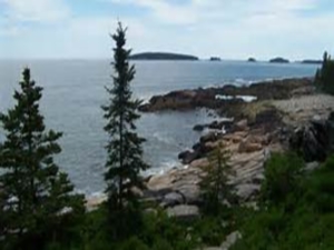
Several of hundreds of islands, once the tops of hills, along the coast of Down East Maine – Internet photo
In January Red Caulfield, a friend of the Steam Team, loaned us a little book entitled Casco Bay Yarns by Williams Haynes.1 Red has a knack for finding gems about Yankee lore that probably few have ever read. None ever made bestseller lists, but we like ‘em. Red and good wife Joan have a place Down East at Cundy’s Harbor just a few leagues east of Portland across the island-studded bay that in Hayne’s book continues on east.
The author tells of the early days when the hundreds of islands along the ragged coast around the Gulf of Maine were known to Old Worlders, but only from the sea. The interior, a mystery to them, was populated by the spunky Abnaki.2 The fishermen, explorers, and then colonists, mostly English, were small-ship people who visited and later parked on the edges by the sea. One early explorer estimated there were 365 islands, a year’s worth, in the Casco Bay area. His Casco Bay was much larger than the place by that name on modern maps. It included Cundy’s Harbor and even the islands of Penobscot Bay and perhaps beyond. Someday when we have nothing to do we might find a good chart of the coast and count them.
The Abnakis, like Red, much liked their summer homes and playgrounds along the seafood rich coastal islands. They weren’t at all pleased to find the newcomers there making claims granted by distant unseen chiefs with strange names. Many of the English didn’t even bother with the niceties of artificial legal ownership. They simply squatted until driven out by stronger colonists or later by fed up Abnakis. Haynes goes on and on about the wheelings and dealings of men with guns, iron goods, trinkets and ever more of their strange countrymen seeking land. This skullduggery continued for well over a century past the first attempt in 1607 by the failed settlement, the Popham Colony, near the mouth of the Kennebec River3. The French, north along the St. Lawrence River, worried about the English moving north and east. They helped the Abnakis, thus greatly complicating the mix. Folks here in seemingly distant Salem, which then included what are now Middleton, Danvers, Beverly and Peabody, were very much involved with the Down East islands and bays. People here knew more about small settlements like Falmouth, an early name for Portland, than they did of Andover and Concord. There was much easy sailing in small ships and boats back and forth. Historian Mary Beth Norton in her book In the Devil’s Snare blames the witch hysteria here partly on fears of the Abnaki and French “devils” there4. Salem and Falmouth shared kin who often moved between them during the Indian attacks in the Casco Bay area. During the late 17th /early 18th century’s Indian wars fear and worry ran deep. We suspect the Puritans’ worries were less than those of the displaced and disease decimated Indians.
While reading Hayne’s entertaining history, devoid of footnotes or bibliography that might have cramped his style, we borrowed a detailed atlas of Maine from another lover of that state. One old Closeteer had spent half a life of daydreams imagining boat trips powered by oars and sprit sail among the islands. Long a teacher with a couple months off each summer he had access to his school’s dories. Alas, summer workshops, classes, chores in preparation for the coming year, and family obligations kept him close to home. The plan, vivid at times, was to row and sail island to island camping each night in beckoning lonely coves. He knew thousands shared the same dream, and that some had the money and time to realize it. A couple colleagues returned each late summer and told real stories of sailing among these islands. They, of course, didn’t travel as simply as he planned, which pleased him; his explorations would be different.
With atlas laid out on the Water Closet table, the dreams weakly returned to the Closeteer now old. They are almost better today because he knows the trips won’t happen. Plans can be made but nothing concrete need be done. He had his chances. A couple surviving dories await someone else. The spruce and fir covered granite isles with tidal skirts of wrack are still there. Twice each day while singing surfy songs these sirens call and show wet ankle. They were once the ridge tops of ranges that became partially inundated. In the last 12,000 years, the Wisconsin continental glacier’s ice melted and the ocean rose. Seawater flowed up valleys. Fifty or so south pointing peninsulas seemingly drip down from the mainland, Eastport to Cape Elizabeth. The higher points on these ridges became islands, hundreds of them. Once they were encircled each summer by Abnaki canoes, squaw clammers, and young swimmers. Now they are ringed with lobster pots and passing yachts.
1 Casco Bay Yarns by Williams Haynes was first published in 1916,
2 Abnaki also spelled Abenaki, Wabnaki – Algonquian speaking tribe with many sub tribes in what is now northern New England, New York and southern Quebec.
3 The Popham Colony (also Sagadahoc Colony) lasted one year and then its survivors returned to England. Its greatest success was building the first ocean going ship built by the English in the New World. Virginia was the penance’s name. Remains of the small colony were found in 1994.
4 In the Devil’s Snare by Mary Beth Norton was published in 2003.
WATER RESOURCE AND CONSERVATION INFORMATION
FOR MIDDLETON, BOXFORD AND TOPSFIELD
| Precipitation Data* for Month of: | Nov | Dec | Jan | Feb | ||
| 30 Year Normal (1981 – 2010) Inches | 4.55 | 4.12 | 3.40 | 3.25 | ||
| 2013 – 14 Central Watershed Actual | 3.35 | 5.30 | 4.40** | 0.20 as of 2/4** | ||
Ipswich R. Flow Rate (S. Middleton USGS Gage) in Cubic Feet/ Second (CFS):
For Feb 4, 2014: Normal . . . 66 CFS Current Rate . . . 49 CFS
—————————————————————————————————–
*Danvers Water Filtration Plant, Lake Street, Middleton is the source for actual precipitation data thru Dec. Normals data is from the National Climatic Data Center.
**Updated Jan and Feb precipitation data is from MST gage.
THE WATER CLOSET is provided by the Middleton Stream Team: www.middletonstreamteam.org or <MSTMiddletonMA@gmail.com> or (978) 777-4584
