Water Closet for May 22, 2015
[pullquote]”In Middleton the tributaries, from upriver down, are Flint Brook, Punchards Brook, Middleton Brook, Emerson Brook, Boston Brook, and Nichols Brook.”[/pullquote]At the turn of the millennium the three year old Middleton Stream Team decided that the town’s little known streams needed name-posts. Had they thought of this earlier the founders might have called their new group the Brook Bunch since the named streams in town are all “Something” Brook. They took the road most traveled and went with Stream Team, of which there are a score or more around the state. Had they gone with “brook” members might be called “Brookies” like the trout instead of Stream Teamers. Team is probably better for members who work well together.

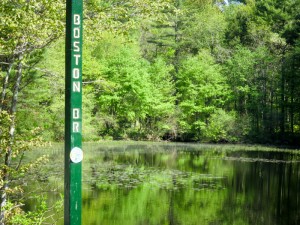
Middleton Stream Team signpost where Boston Brook passes under North Liberty Street into Prichards Pond. – Judy Schneider photo
We Stream Teamers found out that naming creeks was not as easy as anticipated. Several of six brooks converging with the Ipswich River in town had more than one name. Two fairly substantial brooks had none. We would have used the Algonquian names of the Naumkeags and Agawams but they and their place names are long gone. The English who took over called the river Agawam for awhile which was probably wrong. Some say Agawam is a corrupted name for Masconomet’s people who lived in the river’s lower watershed. The river ended up being named after Ipswich, England. We Ipswich River Watershedders don’t know of a single Indian name for any hill or river in the whole watershed. They were here 10,000 years before just a century or so of dying of Old World diseases or moving on after the newcomers with their hoofed animals arrived. It is unfortunate because Indian names are usually descriptive; for example Merrimack is from Merrohawke meaning strong current as the river was all along its length before being impeded by dams. Nashua signifies beautiful stream with pebbly bottom.

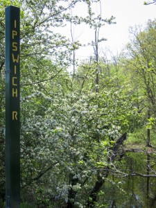
One of 25 signposts at road crossings over streams and river in Middleton. This post is attached to the Peabody Street Bridge where it crosses over the Ipswich River. – Judy Schneider photo
So we were largely left with the English names of farmers and millers whose fields flanked the brooks. In Middleton the tributaries, from upriver down, are Flint Brook, Punchards Brook, Middleton Brook, Emerson Brook, Boston Brook, and Nichols Brook. The Stream Team asked the selectmen that an unnamed brook in the very south of town just down river from North Reading be named Flint Brook after John Flint a very prominent farmer and mill owner who owned the land surrounding the half-mile long stream that once had a sawmill. We were later uncomfortable with this request upon learning that Flint kept slaves who worked the fields along the brook. There are no markers on their graves in the Flint and Woodward family cemetery on Boston Street. Too late now, the selectmen approved our request; Flint Brook sign posts at Boston Street and River Street crossings were put up.
The next brook of any size entering the river is Punchards Brook. This mile-long, but little known brook drains much of the area encompassed by South Main, River and Boston streets. The only paved road crossing over Punchards Brook is River Street near the Town Transfer Station; not long ago “the dump”. Passersby do not see the stream overgrown with vegetation on both sides of the street. They do see our 4 x 4 inch, 7 or 8 feet tall, green painted, fir sign posts with PUNCHARDS BR routed by Francis Masse on two sides. The purpose of all 25 posts is not to remember bygone farmers but rather to serve as stream or river markers. All but one of the six listed are “rivers” under the Rivers Protection Act. We could have used flashing neon lights heralding STREAM or RIVER to let folks know of them, the system of transport and much more long, long, before roads.
Let’s paddle on down the Ipswich River from where Punchards flows over a broad front through a scrub-shrub swamp to converge unseen with the river. After another serpentine mile Middleton Brook joins the river, also quietly entering through a swamp flanked by Richardson Farm’s fields. It, crossed-over by three roads near the town center, is marked at each by signposts. On a late 20th century plan we found the name Richardson Brook. On other maps it is Middleton Brook which carries water via Middleton Pond all the way from North Reading. We might have named it Tim’s Brook after an infamous town character in the 1700s. Timothy Fuller, fond of quarrels, was a mill owner and farmer with lots of land. The remains of his sawmill dam can be seen a half mile down creek from Middleton Square if one is willing to bushwhack a bit. Once fast running Middleton Brook has been reduced to the overflow from the Danvers Water Department reservoir called Middleton Pond, once Forest Pond. You can’t trust names, they change.

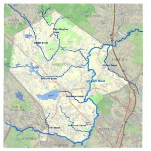
This is a map of the major streams in Middleton flowing to the Ipswich River of which nine of forty miles are shown. – Middleton Town Planner Katrina O’Leary put together from computer maps she added to.
Continuing down river more than a mile past Mortalo Landing at Maple Street, the next tributary, again not really seen entering the river because of dense stands of wetland plants, is Emerson Brook. We found several names for this long stream which brings water all the way from Stearns Pond in North Andover. Going down stream they are Andover Meadow Brook, Emerson Brook, Pout Pond Brook, and Ironworks Brook. Like many other brooks it was named for what it passed. Darius Emerson had a sawmill just west of Lake Street. Its dam once flooded about one-hundred acres above it. Flash boards were removed in late spring and parts of the rich drained bottom land were hayed, pastured, and produced cranberries. The year ‘round inundated swamp above the now larger reservoir dam there is called Emerson Bog, so the Stream Team went with EMERSON BR and had these letters engraved on both sides of six posts. Spirit of town historian Lura Woodside Watkins please forgive us for not using your “Pout Pond Brook”. That name no doubt arose from hornpout caught in Pout Pond, through which the five mile long brook passes northeast of Howe-Manning School. By the way, some, not too many we hope, think that BR is for bridge. Stream Teamers who think brooks, not bridges, would never make that mistake. Masse on his downward rout understandably ran out of post. By abbreviating he was spared from having to rout 150 more letters for 50 OOKs.
Let’s leave Emerson for Boston Brook, one of the river’s longest tributaries which enters just a hundred yards down river from Emerson Brook’s convergence. Nine mile long Boston Brook comes down from the highlands of Holt and Boston hills, glacial drumlins in North Andover. Boston Hill headwaters might be responsible for the brook’s name. Perhaps when it was bare pasture like almost all our hills in Colonial times Yankee cowboys admired distant Boston from its summit. For country folks before railroads this famous port and capital must have been a rarely visited Mecca. All is not clear about the name for this long creek with four road crossings in Middleton alone. Beechy Brook can be read on old maps and deeds. Were there lovely beech groves above its banks? We can show you a couple now by the brook in back of Henry and Mary Tragert’s, once a Fuller farm, on Essex Street.
On down river we continue until, near Route I-95 and the Topsfield-Middleton bound just beyond, Nichols Brook enters the Ipswich River from the south carrying water two miles from Danvers. It was named after colonist John Nichols a grantee of much land in what is now east Middleton and southwest Topsfield. There is only one post above Nichols Brook, also the Middleton-Topsfield line, on Coppermine Road.
So names as you can see are impermanent, they come and go with people’s whims, survival, and fading knowledge of history. Our 25 sign posts keep names, rather sketchily decided upon, around a little longer. If aliens take over, our brooks might have new unreadable signs for any natives left to puzzle. What we really want is for adventurous, curious folks, especially kids, to get out of cars and off roads to bushwhack along them as we Brookies do.
______________________________________________________________________________WATER RESOURCE AND CONSERVATION INFORMATION FOR MIDDLETON, BOXFORD AND TOPSFIELD`
| Precipitation Data* for Month of: | Feb | March | April | May | |
| 30 Year Normal (1981 – 2010) Inches | 3.25 | 4.65 | 4.53 | 4.06 | |
| 2015 Central Watershed Actual | 3.55 | 3.62 | 2.38 | 0.0 as of 5/18** | |
Ipswich R. Flow Rate (S. Middleton USGS Gage) in Cubic Feet/ Second (CFS):
For May 19, 2015 Normal . . . 64 CFS Current Rate . . . 11 CFS
*Danvers Water Filtration Plant, Lake Street, Middleton is the source for actual precipitation data thru April.
**Middleton Stream Team is source of actual precipitation data for May.
Normals data is from the National Climatic Data Center.
THE WATER CLOSET is provided by the Middleton Stream Team: www.middletonstreamteam.org or <MSTMiddletonMA@gmail.com> or (978) 777-4584