Water Closet for April 4, 2014
Last week as the thick ice on Middleton Pond finally melted around its edges, two old Closeteers from Middleton drove northeast along the river to catch a late afternoon low tide in Ipswich. They said they were seeking clams but we know better. That place where fresh and salt water meet has long pulled them as the moon and sun do the tides. Well not quite, but gravity will soon get them. They go on lows to see the bottom of the estuarine world, twice daily exposed, amidst a wonderland of salt marsh prairie cut by cricks, dunes, and glacial hills. The ice strata welded by several deep cold periods was off the salt marsh grasses and even the fields and south facing wooded slopes of uplands. [pullquote]” They found many dime diameter holes each leading to soft shelled clams, their prey”[/pullquote]The thermometer was up to 40; the gale force northeast winds of the previous 30 hours had subsided. A light breeze blew enough to cheer them and to turn Ipswich’s great turbine blades above the edge of last year’s flattened brown marsh grasses. Within a clear view of Castle Hill, Choates Island and the high dunes of Cranes Beach, they parked beside the road. A well worn path across the salt marsh to “Jennings Ground”,a too popular flat, greeted them as did male red-winged blackbirds in nearby bushes on high ground singing up a storm. The blackbirds’ preparatory songs for the soon to come females were the first the Closeteers had heard this spring. Their ears aren’t what they used to be. Others told them blackbirds had been here for a week. These old but amateur clammers called “mess diggers” followed the track of an earlier arriving pro on the muddy path. They concluded there must be only one clammer at Jennings unless others had come in by boat.
After a pleasant quarter-mile hike on the level marsh, they climbed down the bank of soft peat into softer mud of the tidal flat that tried to take their boots. In ten yards they were on firmer sand-mud among mounds left by clammers who had dug deep in the late fall and winter. They found many dime diameter holes each leading to soft shelled clams, their prey. After digging down 12 inches they knew the clams were lower and that they were in trouble. Eighty plus year old bodies out of shape might not make the 16 inches or so they had to go. A young fellow, the one tracked, was nearby up the salt marsh crick. When asked, “How’s it going?” he said, “They’re deep.”
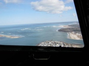
The mouth of the Ipswich River from 1000 feet framed in a helicopter door: Little Neck is below. Castle Hill and Crane Beach are off to right, and the south tip of Plum Island is across the sound to left. The Atlantic feeds and takes from estuarine marshes twice daily. – Stream Team photo
So the old men dug and found it so. Soon they tired with only a third of their allowed ten quarts. No great disappointment or surprise was felt. They knew their clamming days were numbered and that even in summer when the clams moved up and settled within the range of their diggers’ tines they’d not easily fill their pails. They rested a bit and then struggled back through the mud and up the bank as the sun set in the west. The tide, which had turned some time before, had risen behind them and reached their feeble holes. The fresh seawater exuded ocean smells so loved. They could not say they heard the surf on the beach a mile east but they knew that endless song was being sung and would be next time, and long after there was no next time for them. Strangely these were not melancholy thoughts. A pleasant tiredness had them in its grip; in their buckets were enough clams for “a feed”. They’d be well received at home as no doubt the squaws were who dug the same flats long ago.
The sunset was a modest one as befit the day, the spring air soft. The blackbirds were taking a break.
WATER RESOURCE AND CONSERVATION INFORMATION
FOR MIDDLETON, BOXFORD AND TOPSFIELD
| Precipitation Data* for Month of: | Jan | Feb | March | April | |
| 30 Year Normal (1981 – 2010) Inches | 3.40 | 3.25 | 4.65 | 4.53 | |
| 2013 – 14 Central Watershed Actual | 3.47 | 4.34 | 5.00** | 0.00 as of 4/1** | |
Ipswich R. Flow Rate (S. Middleton USGS Gage) in Cubic Feet/ Second (CFS):
For April 1, 2014: Normal . . . 142 CFS Current Rate . . . 562 CFS
*Danvers Water Filtration Plant, Lake Street, Middleton is the source for actual precipitation data thru Feb. Normals data is from the National Climatic Data Center.
**Updated March and April precipitation data is from MST gage.
THE WATER CLOSET is provided by the Middleton Stream Team: www.middletonstreamteam.org or <MSTMiddletonMA@gmail.com> or (978) 777-4584
Feature photo credit: Rachel Ford James via photopin cc
A beautiful version of clamming, as only Pike can do! It has never been about the amount of clams or oysters that gets taken home, its about the good company and the pristine beauty of the Ipswich shores!