The following Water Closet, written by Pike Messenger, is a wonderful and fitting tribute to the efforts of The Middleton Stream Team who worked tirelessly over the last ten plus years to transform five forgotten and overgrown sites along the Ipswich River into clean, inviting and beautiful public spaces highlighting the hidden jewel flowing through our community
* Pike’s Water Closet is now available in a new book! Scroll down to bottom for ordering info.
~~~~~~~~~~~~~~~~~~~~~~~~~~~~~~~~~~~~~~~~~~~~~~
THE WATER CLOSET
LANDINGS ALONG THE RIVER
Along the roads of life there must be places where we stop to smell the water lilies and watch the comforting flow of water. Many of us will go some distance to see water. Why not areas along our river to provide breaks for passers-by on daily chores? In Native American and early English times, streams and rivers were the highways. Shouldn’t we maintain connections between today’s asphalt network and the water one of yore? Even cities of stone and pavement have parks sited along ponds and rivers. Frederick Law Olmstead’s Emerald Necklace in Boston is a famous example.
In 1998 the Middleton Stream Team was formed under the auspices of the Massachusetts Riverways Program with encouragement and help from the Ipswich River Watershed Association. In Middleton, our mother stream, the Ipswich River, receives water from brooks named Flint, Punchards, Middleton, Emerson, Boston and Nichols as encountered, in turn, on a paddle down river from North Reading and Lynnfield to the Topsfield line near I-95. Smaller unnamed brooks feed these tributaries. The team’s initial goal was to watch over the health of these streams and their wetlands.
Members of the team soon became interested in public access to the river at various road crossings in town. At each intersection there were shabby, small parking areas that attracted trash. In 2002 the team learned through the Conservation Commission that an acre lot on the river at South Main Street (Route 114) across from Danvers was town land that had been taken by tax title. The long neglected place, once a stone yard, was covered with discarded

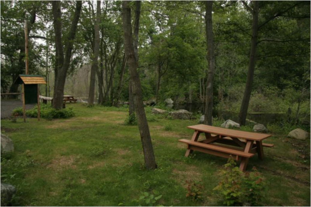
Farnsworth Landing – Late summer. Photo by Judy Schneider
stone fragments, bushes, briars, and patches of asphalt surrounded by a rusting cyclone fence. The stone business was gone; its debris was not. The team asked the town if it could clean up the lot and make a park. The town fathers said O.K. and many volunteers with the blessing of the Conservation Commission went to work. Within three years it had become the lovely park you see today named Farnsworth Landing1 after the late river champion and long time conservation commissioner, Raymond A. Farnsworth. Of the team’s now five parks, this, the first, is considered our cardinal flower. Many people off the busy highway stop each day to take a break. There are two picnic tables and a fine large flat rock as well as stone steps to dine on. The debris has been replaced by lawn, trimmed trees, flowers beds, and a crushed stone parking area. When the land was taken over, there were rotting wooden steps leading to the river, once access for paddlers. We asked Middleton contractor Vito Mortalo about a proper landing. He from Italy, an American for 45 years and a stone lover pooh-poohed short lived wooden stairways and built us a beauty of stones at very little cost to the town. Thousands have used the Farnsworth park-landing since it was named and formally dedicated to the town in 2005. Middleton’s Department of Public Works (DPW) and Stream Teamers maintain it with some cleanup help from users.

Farnsworth Landing – Angler in pink checks her line on Vito’s steps. Photo by Katharine Brown
After admiring the “kiosk”, a cedar-roofed and cedar post-supported display board, with a river map and nature trail information at Farnsworth’s, and after visiting a commemorative stone with a bronze plaque given by his family, we get underway for the team’s next landing one-half mile down river off Log Bridge Road. In 2007 Xavier Chambers, an aspiring Eagle Scout of Middleton’s Troop 19, under Steam Team sponsorship, took on the project of turning a roadside dump there into a park-landing. From early colonial times right up until 1972 a bridge, once made of logs, crossed the river from then “Salem Village” to “Salem Farms”. Salem Village later became Danvers and in 1728 Salem Farms became Middleton. In the 17th and 18th centuries it was a key point along the main cart path from Salem to Andover. Most transport between those early colonial towns was by sea around Cape Ann and via the Merrimack River. Chambers, other Troop 19 scouts, and volunteer Middleton contractor Timothy Willey with his men and heavy machinery did a fine job. Several other contractors and friends also helped. Chambers coordinated all the volunteers’ activity and became a deserving Eagle Scout and valued friend of the Stream Team. This landing and mini-park with picnic table and kiosk with map and other information is a quiet place to escape the bustle of commerce. A bronze plaque on stone tells the history of the onetime bridge. The land between the road and river bank above the old bridge abutment is no longer used as a dump. Often on our rounds we’ve seen people resting there, watching water and wildlife. Although all the land is in Middleton, half is owned by Danvers, the other by the state2.

Window on Wetlands Park – Stream Teamer, Francis Masse, with wheelbarrow works on nature trail. Photo by Judy Schneider
A fine four-acre stand of mature hardwoods and pine called “Window on Wetlands” begins just a 300-ft. walk up Birch Street along the river. In 2008, the Stream Team sponsored another Eagle Scout project led by David Florance of Troop 19, to develop this into a nature park. This woodland now has a 700-foot loop nature trail along the river’s wetlands. This park without river access is also on state land.2 Visit and walk its trail along the floodplain. You’ll pass under some huge red oaks. During major floods nearly the whole area is under water.
After returning to Log Bridge landing, we descend granite steps to our canoes and kayaks waiting to continue with the seaward flow. The next two great meanders flanked by dead ash and swamp white oaks appear grim to some. Large beaver dams down river have drowned acres of trees. Many trunks, gray corpses, still stand. The light now pours in making the impoundment rich wildlife habitat. Muskrat lodges are seen among fallen trees. An hour or two later, depending on conditions, after having passed Richardson Farm fields, we paddle under the Maple Street (Route 62) bridge into a cove below Mortalo Landing, yet another Stream Team mini-park. Vito Mortalo artistically placed magnificent stones steps leading from the water up to it. Some of the carefully selected natural stones are 3 by 6 feet. At their top is a small parking area and lawn ringed in back by an oak-locust rail fence. In 2006 the state2, which owns the lot, approved the Stream Team’s request to clean up this wooded dump where long ago there had been a small house. In 2011 the project was finished. The Selectmen upon recommendation of the Stream Team named it Mortalo Landing in honor of stone artist Vito. Landscaper friend Glenn Bambury voluntarily helps the Stream Team and DPW maintain it.
Before leaving Mortalo Landing, we visit one of Topsfield Boy Scout Peter Sacco’s fine kiosks with educational displays. Under Stream Team sponsorship he and other scout volunteers built and installed six such kiosks at various landings along the river from Middleton to Hamilton. Stream Team leader John Bacon served as Peter’s mentor for this impressive Eagle Scout project. After admiring Peter and Masconomet art students fine displays we descend Vito’s steps and are underway again.3
After a lovely mile of meanders flanked by wooded uplands, we come upon a pleasant clearing called Rachel’s Rest honoring the team’s hero, Rachel Carson. This flat area where once a summer cottage stood was made into a place for the paddling public a half century past, and then neglected. A decade ago, the Stream Team took it over; cleared it again and planted a buffer of white pines on the north side. Wild flowers and those from the long ago owners’ garden now thrive. A sign reminding folks of the late Carson and inviting paddlers to stop and rest awhile is on the river’s edge. Rachel’s Rest is on town land and a parcel to the west abutting Mill Street owned by the state. The clearing has no street access other than a narrow, little known, woodland path to Mill Street. This shady rest and picnic spot is for paddlers off the water.
From Rachel’s Rest, in less than a very pleasant mile, our tiny fleet rounds a bend beneath Greenbelt’s mowed fields off Peabody Street. Before us is another Mortalo creation of stones beautifully positioned on the river’s edge of our Peabody Street landing project. The great stones in and just above the water are perfect platforms for play and relaxation. In 2002 the team was awarded a

Peabody Street Landing – Rachel Schneider, friend of the Ipswich River, sits on one of Vito’s stones. Do her thoughts join the flow down to the sea? Note Stream Team’s informational kiosk in the background. Photo by Judy Schneider
small grant from the Massachusetts Department of Fisheries and Wildlife to help with the project. This landing is on state land.2 Its small parking area and lawn, which replaced a long muddy puddle, was finished in 2004. The park has an informational kiosk with map and photos, and a picnic table. In summer we prefer to sit on Vito’s great stones, feet dangling in the water. No time now, let’s continue a half mile further down river to Thunder Bridge.

Peabody Street Landing – It is spring, perhaps the boys are daring each other to go for an early swim. Photo by Judy Schneider
The trucked in sand beach below Thunder Bridge, East Street, is the town’s public swimming hole. It too is a good place to put in and take out kayaks and canoes. There is plenty of parking except on hot summer days. Another of Peter’s handsome kiosks graces the back lawn. Masco student artists helped him with the fine educational displays of all his kiosks.3 We could continue on to Topsfield, another half mile or so, or on to the sea about 17 miles. We’ll take out here and leave that for another day or two.
In our roughly eight mile paddle down from Middleton’s southwest boundary, where there is not yet a proper landing, we stopped at five that were barely usable or even known a decade ago. These attractive parks made by and provided for by diverse volunteers with DPW help at virtually no cost to the town are open to all. When on our periodic checks, we’ve seen citizens napping, eating, drinking, smoking, chatting, phoning, kissing, reading, fishing, stretching legs, exercising dogs, playing with children, putting in and taking out kayaks and canoes, or just sitting, seemingly doing nothing but watching the water flow by. Our favorite times at the landings are during spring and fall cleanups when with wheel barrows, saws, rakes, and shovels we happily work together as a “team” without a thought as to who is winning.
1. Raymond A. Farnsworth Canoe Landing and Conservation Area is the full name.
2. The land upon which three of our five parks are located is owned by Massachusetts under its Division of Capital Asset Management. These parcels were turned over by Essex County to the state a generation ago. The Stream Team would like the parcels turned over to the Department of Fish and Game to be protected as conservation land, their original purpose under the county. We are preparing a letter to the Department of Fish and Game asking that a bill to be submitted to the Great and General Court.
3. Masconomet student and Topsfield Troop 81 Boy Scout, Peter Sacco, with the help of his father, fellow scouts, a Masconomet art class, mentor Stream Leader John Bacon, and Stream Steam advisor Robert Lemoine gave a grand gift to the river in the form of six very attractive display kiosks at key sites along the river. It would take a booklet to describe just the planning, which included many meetings with town boards and officials. The project was later recognized as the most outstanding of all the Eagle Scout projects in the Yankee Clipper Council in 2011. Peter, now attending George Washington University, visits John from time to time. We all visit and admire their kiosks when going by on water or road.
THE WATER CLOSET is provided by the Middleton Stream Team: www.middletonstreamteam.org
~~~~~~~~~~~~~
The Water Closet – A New Book by Pike Messenger
NOW AVAILABLE (HOT OFF THE PRESS!)
Three hundred essays published from 2006 through 2011 cover a wide range of “wet” subjects from alewives, to glacier sculpted local landscapes, to Indian and Colonial land use, to local water animals and plants, to floods, etc.
Now available from: Amazon