Water Closet for September 8, 2017
On a fine August Sunday afternoon, 11 paddlers in four kayaks and three canoes put in on a half-tide ebb at the end of Island Road in Essex. [pullquote]”Soft shelled clams, razor clams and an occasional quahog were dug by hand, studied, and soon released to watch their return to a wonderfully clean habitat”[/pullquote]Throughout the year when the flats are open clam diggers depart from this landing as low tide approaches. Up until the 1600s the clammers were Indian women and girls carrying forked digging sticks and woven baskets. But the eleven paddlers on Sunday weren’t after food; they had brought their own. Crane Beach and Choate Island were their goals. En route the wind and tide were with them; paddling was easy even for several novices.
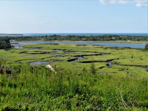
Plum Island in the background left, vegetated Crane Beach dunes, and labyrinth of salt marsh cricks at low tide as seen from the summit of Choate, also called, Hog Island. -Elaine Gauthier photo
The wide cricks they traveled cut through layers of soft brown peat, capped by green salt grasses, showed the strata formed over time. One measurement from a mid 20th century Newbury study has had the marsh surface rising with the sea on an average four inches every 100 years in the last millennium. Since the deepest and oldest peat is about 360 inches thick and about 3000 years old there must have been much faster periods of sedimentation and rise. The level marshes are covered by grasses and rushes that catch sediment at high-runner-tides thus getting thicker. If the sea rise due to global warming continues as it has been, peat formation may keep up. If it rises faster the protective barrier beaches will be overridden and eroded, the soft marshes washed away.
The fleet of little vessels swung around to the east under Choate Island, a drumlin left by the continental glaciers looming above the marsh.
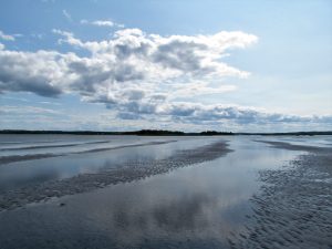
Waves of clean sand on Essex bar at low tide – Elaine Gauthier photo
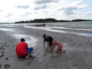
The backside of the dunes of Crane Beach came into view. The group planned to swim from its almost white sand beach, which on Sunday was surprisingly crowded. The paddlers gammed, hollered back and forth to one another as from passing ships of old, and decided they wanted privacy. The opportunity arose below them. The falling tide on the broad bar they were crossing had clear water only ankle deep and falling. Their vessels were soon grounded on soft sand. The channel nearby provided water deep enough for swimming. The paddlers decided to picnic on the bar. Their newly exposed beach was 200 yards off the one with motorboats and people.
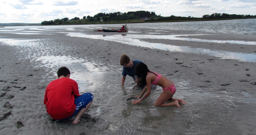
Left to right: Amiri, Django, and Jia dig with hands in an Essex low tide sand bar for clams to study and then release. – Elaine Gauthier photo
As they ate, talked and swam, they discovered holes in the sand. Soft shelled clams, razor clams and an occasional quahog were dug by hand, studied, and soon released to watch their return to a wonderfully clean habitat. The razor clam quickly extended a foot and pointed it downward into the sand. Water was pumped into the foot’s end thus making a bulbous kedge anchor. Muscles pulled the clam upright and then down. An old timer, patriarch of the group, said you can eat raw clams like oysters. He would have demonstrated but was voted down. The diggers didn’t want their catches killed. The lovely bar, no oyster bar, was a place where mercy prevailed that Sunday. All the animals captured and studied were let go. Later on return, on a rising tide, hermit crabs in large numbers put on quite a show. On the channel’s flanking mud flats three serious clammers with a lively dog tried kiddingly to sell clams to the paddlers stranded by the too shallow water. The dog befriended by the paddlers’ leader followed her and had to be returned. There was much barking, calling and dashing around on the flat until rising water allowed the fleet to proceed.
The swim and picnic over, the fleet turned westward toward the southeast toe of slope of Choate or Hog Island, both names are used. The glacial drumlin rises gently from the southeast to its summit 180 feet above the sea. The north end and its steep flanks are shaded by mature European spruces which were planted by Cornelius and Mine Crane, Choate’s new owners in the 1930s.
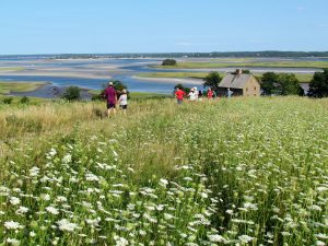
Paddlers are climbing Choate Island in a southeast sloping field of flowers, in patch of Queen Anne’s lace. Cape Anne is in the background beyond the Essex marshes and river. The three century old Choate house, featured in the movie The Crucible, stands alone on the right. – Elaine Gauthier photo
The visitors hiked slowly up from the handsome old Choate House, seen briefly by millions around the world in the 1996 movie The Crucible. The slow ascent was due to frequent pauses as the climbers stopped and marveled at the Atlantic’s edges as they were revealed in all their glory. Other drumlins including Castle Hill; the barrier beaches of Crane, Plum Island, Salisbury, Seabrook, and Hampton to the northwest and north; distant Mount Agementicus in Maine; the Isles of Shoals barely seen a little east of north; the mighty open ocean all the way east to Cape Ann and beyond; and then the uplands back around to West Gloucester and Essex, all wore the soft colors of summer. And at low tide stretching out below the hill were the wide salt marshes. The rich estuary’s colors of greens, browns, and whites and all shades in between swirled amongst each other in most delightful patterns. All about the dawdling climbers, flowers filled the field, some in bloom, others passing. A few monarch butterflies, whose diminished populations are now much worried about, flitted among patches of milkweed. In the lovely meadow were a dozen recognized flowering plant species. A botanist could have named many more.
A team of botanists, zoologists, microbiologists, geologists, and hydrologists is needed to begin to understand the many layers of life of estuaries and their surrounds. For other dimensions add to them the artists in us all who in awe simply wade and paddle. Patches of wet flat and bar are dynamic paintings brushed by tides and wind. The coming and going twice daily of clear seawater and the murky waters from cricks creates Escher patterns of rivulets and sand-mud dimples like tiny dunes that snails, green crabs and hermit crabs move about on and in. When the water deepens, minnows, sand eels, and sea worms come forth. The bars, flats and cricks are alive with ever-renewed levels of life. And so were the temporarily stranded paddlers as they, released by a rising tide, paddled homeward toward a setting sun.
___________________________________________________________
WATER RESOURCE AND CONSERVATION INFORMATION
FOR MIDDLETON, BOXFORD AND TOPSFIELD
`
| Precipitation Data* for Month of: | May | June | July | Aug | |
| 30 Year Normal (1981 – 2010) Inches | 4.06 | 3.95 | 3.89 | 3.37 | |
| 2017 Central Watershed Actual | 4.87 | 6.08 | 3.43 | 1.9 as of Aug 31 | |
——————————————————————–
*Danvers Water Filtration Plant, Lake Street, Middleton is the source for actual precipitation data thru July.
** Middleton Stream Team is the source of actual precipitation data for Aug..
THE WATER CLOSET is provided by the Middleton Stream Team: www.middletonstreamteam.org or <MSTMiddletonMA@gmail.com>
mpo168 hello my website is mpo168
jnttoto hello my website is jnttoto
cupple hello my website is cupple
banda55 hello my website is banda55
fossil hello my website is fossil
qqremi hello my website is qqremi
vani hello my website is vani
jsEncrypt hello my website is jsEncrypt
Thank you so much for the descriptive and educational words that told the exciting story of your trip to Choate Island. I felt as though I was right there with the group.