
Water Closet for May 30, 2014
What some wag dubbed “the fires of liberty” have a long history along Middleton’s heavily forested North Liberty Street. A dozen times in the last 30 years there have been significant fires in the mixed hardwoods to the east and west of that unpaved road. A couple fires in the past decade swept over 200 acres of leaf and stick covered ground. Middleton’s Council on Aging/Conservation Commission hikers encircled the blackened area of the latest woodland fire last Friday. It is along a Middleton Hiking Trail called Anne’s Land.1
In early May a wood’s fire on high dry ledge dominated by fifty or so year old white oaks with adjacent low spots containing vernal pools bounded to the north and south by true bogs kept Middleton firefighters and brethren from surrounding towns busy for half a day.
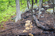
As the leaves were coming forth in early May a fire skipped lightly over this oak dominated forest on high ledge. The damper lower ground cover to the left was untouched. The thick barked oaks were unaffected. Small pines like the one here center front were killed. Note rocks scattered by the glacier.
Judy Schneider photo.
The lows around the highs were damp so the flames didn’t spread much beyond 20 acres of forest floor duff. Almost all things having to do with fire involve water. At the same time as our fire, the fires in the dry hills of San Diego County were out of control. Thousands of acres were more than just scorched. The fire burned right down into dry soil. With a predicted very dry summer in California more is anticipated. As of this writing, to the east in Arizona a large fire is raging in Oak Creek Canyon between Sedona and Flagstaff. The blaze at Anne’s was a typical spring wood’s fire here. It tiptoed across the surface fueled by upper layers of dry leaves and twigs. The parts of huckleberry and low blueberry bushes above ground were largely killed, their roots were not. A better crop from new stems will come next year because of the burn. Almost all the white pine trees five inches or less in diameter at ground level with thin bark died. Their leaves called needles are brown. The young pines were understory beneath a white oak canopy. The Indians here, perhaps for as long ago as 9,000 years2, knew this and once or twice a year, fall and spring purposely set fires.

Artists Dryness, Breeze, and Fire teamed up to create this temporary painting on acres of oak forest floor. Briefly the creation was hot. Smaller plants died or were set back some.
– Judy Schneider photo
The heat killed seedlings and saplings without thick protective bark left the land savannah-like with well spaced large American chestnut, white oak, and hickory trees, valuable sources of edible acorns and nuts. The open land between the fire-adapted trees was covered with lush grasses, flowers, and berries. Deer and other game animals flocked to them in season. In the Closet we like the story of the early colonists led by John Winthrop sailing for John Endecott’s village Naumkeag, later Salem, and arriving in June 1630. His ship Arbella and four others stopped in what became Gloucester Harbor after “a long and stormy passage” with miserable food. Crew and colonists certainly marveled at the welcoming greens of early summer. Winthrop wrote, “most of our people went on Shore upon the land of Cape Ann, which lay very near us, and gathered a store of fine strawberries.”3 They must have thought they were in Puritan heaven. Many early explorers and later colonists wrote of the abundance of berries found in the vast meadows of New England maintained by Indian fires. Winthrop and company sailed on to Naumkeag fields of what was soon called Salem. Early Salem was a large area that included what became Marblehead, Beverly, Peabody, Danvers, and Middleton. The relatively open flat lands of what became the latter three were then called “The Farms”. This berry happy story was not a happy one for the Naumkeags. Most had died a dozen years before, victims of Old World diseases. The few survivors soon lost their meadows to the ambitious newcomers.
Fires were a natural phenomena long before Indian burnings, land owning farmers, and 20th century fire fighting policies championed by Smokey the Bear. They opened up forested land for natural fodder and fruit for wildlife. Burning released to the soil nutrients from fallen trees and leaves such as potash and phosphorus. Rotting does the same more slowly. They reduced the fuel available for hot, soil-burning fires that result in erosion such as California is suffering now. There are a couple small spots not far from North Liberty Street where a few years ago fire burned deep and even killed mature oaks. Fire also reduces plant damaging insects and fungi. Many foresters around the country have consigned Smokey to a back room office and have taken down his once common signs. One old Closeteer asked Middleton’s Fire Chief to have controlled burns in the interest of practice, physical fitness, and forest fuel reduction. The Chief said little, just politely smiled.
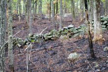
An oak forest floor after a recent fire. The charred spots are temporary; the two-century old wall is not. The single trees, each from an acorn, tell us this was rocky pasture fifty or so years ago. – Judy Schneider photo
Stream Teamers, Closeteers, and Friday morning hikers like to visit past burned areas to enjoy the more open vistas under the canopies of culled, less dense forests with lovely knee-high huckleberry ground cover. Charred tree trunk bases of survivors and dead snags remind us of past benefactors.
Visit each year and compare with unburned areas. Imagine when fires were people-started here every year. Such thoughts open the mind as well as the woods.
1 Wessels, Tom. Reading the Forested Landscape. (The Countryman Press, Woodstock) 1999, is a favorite book in the Closet. Crackerjack naturalist-detective Wessels wanders through woods and fields looking for clues to what happened on the land in the past. He often finds fire a guilty party. No charges are made.
2 Anne’s Land is named for Anne Cote who turned over 30 acres to Greenbelt for a bargain price. See pages 27-31 of Middleton’s trail book Hiking for Health and History , 2011.
3 Page 361, History of Essex County 1878, Salem chapters by Charles S. Osgood and Henry M. Batchelder
___________________________________________________________________-
WATER RESOURCE AND CONSERVATION INFORMATION
FOR MIDDLETON, BOXFORD AND TOPSFIELD
| Precipitation Data* for Month of: | Feb | March | April | May | |
| 30 Year Normal (1981 – 2010) Inches | 3.25 | 4.65 | 4.53 | 4.06 | |
| 2013 – 14 Central Watershed Actual | 4.34 | 4.32 | 2.86 | 2.2 as of 5/27** | |
Ipswich R. Flow Rate(S. Middleton USGS Gage) in Cubic Feet/ Second (CFS):
For May 27, 2014: Normal . . . 59 CFS Current Rate . . . 40 CFS
*Danvers Water Filtration Plant, Lake Street, Middleton is the source for actual precipitation data thru April. Normalsdata is from the National Climatic Data Center.
**Updated May precipitation data is from MST gage..
THE WATER CLOSET is provided by the Middleton Stream Team: www.middletonstreamteam.org or <MSTMiddletonMA@gmail.com> or (978) 777-4584