Water Closet for March 23, 2018
[pullquote]”What a wonder are the lands set aside for us all by conservation trusts such as TTOR and Greenbelt.”[/pullquote]
During the night of the 7th and 8th of March the second storm in a week blew in from the ocean. At northeast-facing Crane Beach, Ipswich, it left a couple miles of wide piles of rockweed above the usual wrack line. In some stretches the alga Ascophyllum nodosum with a mix of other sea debris is two feet thick under a thin layer of new snow. The ocean, still restless the day after the storm, leaped high over sand bars in the entrance to the Ipswich River and Plum Island Sound. The old Closeteer and Rings Island friend upon arrival in the slushy Trustees of Reservation (TTOR) parking lot found the wind off the sea still wet and raw. The pair walked easterly along the largest wrack line they’d ever seen and wondered about its unseen arrival during winter storms after long trips down from the rocky coasts of Maine and Nova Scotia.
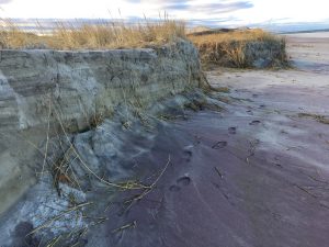
Wind and spray off the ocean sculpted these high dunes at the east of Crane Beach. Note purple bands of agate sand. – Elaine Gauthier photo
The Closeteer as a lad had gathered seaweed after such storms at Salisbury beach with farmer Uncle Bill for use upon the land. The Rings Islander wanted some for her tiny garden. With a front-end loader, huge wagon drawn by a big tractor, lots of help and permission from TTOR she might have gotten enough to cover the fields of Essex County ankle deep. For her around-the-house garden she needed but a couple bags. The two friends talked of dragging some of the seaweed off but decided to wait for easy pickings along paved causeways, recipients of drift cord grass from the salt marshes and at times seaweed torn by great storms off distant rocks. The Closeteer gathers cord grass or thatch, Spartina alterniflora, each year for mulch. In the old days drifting cord grass, cut free by ice and brought to our coastal roads free-of-charge via storms, was gathered and piled against house foundations and sills for insulation. In Colonial times it was cut from the salt marsh cricks’ and rivers’ banks in summer for roof thatch.
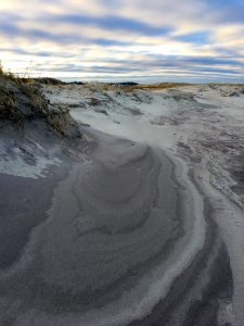
Crane Beach erosion, January 2017 after storm. In the winter sand is removed from upper beach and carried out to offshore bars. Here cut made by storm waves is seen in dune grass terrace above the tidal beach. – Elaine Gauthier photo
After a somewhat gloomy mile in damp air under gray fast moving clouds the walkers, now arm in arm for companionship and warmth, turned south on a path through the dune grass above the tide and storm-washed cluttered beach. They were on a path marked by the Trustees up through the deep-rooted grass that holds the higher beach in place. Gradually they climbed among pitch pines, gnarled choke cherries, and patches of gray birches with openings of low dune grass and beach heather in between. Mother Nature couldn’t have designed a more delightful mix of clearings, shallow pools, groves of trees and bushes in the troughs and crests of dunes, most on a slant. Her night-before storm had most of the sandy ground covered with snow. The visitors’ feet were in untouched new snow which they occasionally sampled and drank from. Now and then snowballs were gently thrown at one another. Crane’s several miles of paths meander round and up and down among long ago treeless dunes. The livestock who for over two centuries had kept them so had long been removed. During the previous night’s storm swaths of sand swept were kept clear by the fickle wind gusts among the dunes. In most places the gale force winds had allowed snow to accumulate an inch to half a foot. As the sky lightened a bit to the southwest the couple glimpsed the sun through veils of thinning clouds. The greens of the pines, lichen and mosses on the black trunks of twisted cherries took on color, some glowing emerald green. The visitors’ blood warmed while hiking in the lee of dunes and now and then direct sunlight. This enhanced their joy and wonder as they rounded and climbed over the wind sculpted topography. In over two hours of leisurely hiking they stopped many times to admire each new scene close up, like delicate mosses and melting snow on trees, and to gaze beyond at more distant views of salt marshes; glacial drumlins, to the south and west such as Choate Island and Castle Hill; Plum Island north across Ipswich Sound, the turbulent entrance to the Ipswich River; and behind the steel gray ocean without end to north and east. They had the whole of Crane Reservation pretty much to themselves people-wise. Only one other car had been in the huge lot back at the start. Deer were nearby. The walkers now and then came upon their tracks crossing the designated paths which deer ignore. On rounding one dune they spotted a distant coyote, its fine winter coat surrounded by white was glowing. At one point the Rings Islander saw several deer scamper into a cluster of pines high upon a dune. Her alert was too late for the Closeteer who was looking out across the marsh at Choate Island.
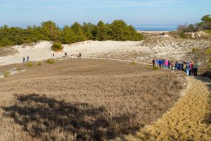
Photo of New Year’s Day Trustees of Reservation hiking group taken several years ago from the high dunes of Crane Beach Reservation in Ipswich. White sand, patches of snow, pitch pine grove, and a large of patch of beach heather fill the foreground. Ipswich Bay is seen beyond. Our barrier beaches are wondrous places largely sculped by winter storms. – Judy Schneider photo
The clouds broke open to the southwest allowing short periods of unfiltered sunlight among the dunes. Snow, storm-plastered on the north sides of trees making them look like birches, slid off in chunks that splashed with delightful gurgles into the pools of wooded hollows. Those sounds broke the somber mood evoked by the background drone of surf. The wind when met on dune crests had become dryer; its cold stimulating to warm faces.
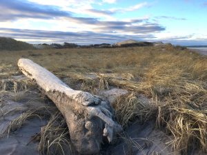
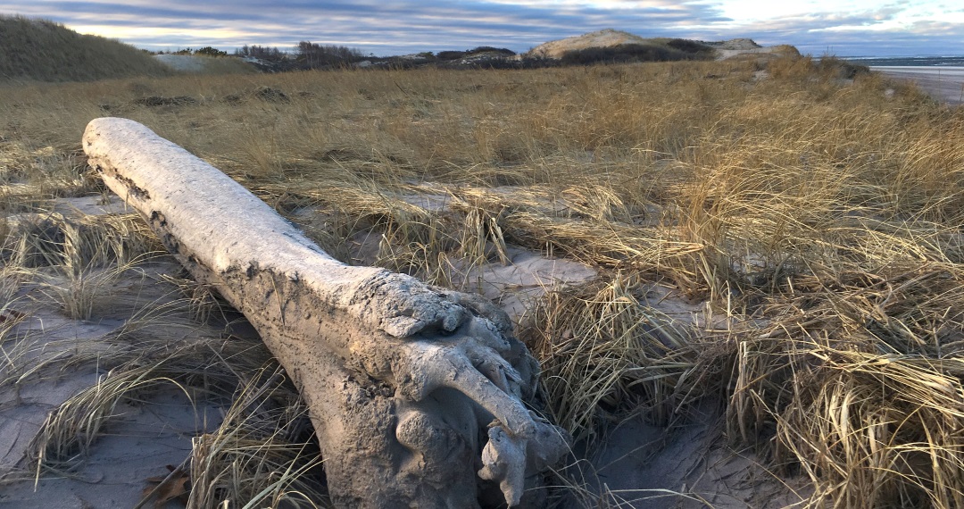
Large drift log floated upon the dune grass shows the power of our winter storms such as the three we’ve had in early March this year. A massive amount of drift seaweed was cast upon the high beach this winter. – Elaine Gauthier photo
What a wonder are the lands set aside for us all by conservation trusts such as TTOR and Greenbelt. One week we might visit the high barrens on Weir, Holt, and Boston hills in the Andovers and look out over the county and distant Boston, the next hike on the beaches of Crane Reservation and Plum Island, the latter protected by Federal and State governments. Middleton Stream Teamers with the coming of spring are talking of another paddle in salt marsh rivers to the Trustees’ Choate Island in back of the dunes of Crane Beach. From its summit the winter ravaged coast can be admired from Boars Head, Hampton, to Rockport, Cape Ann. Millions of tons of sand removed from beaches by the winter storms are stored in offshore bars. The gentler summer waves and currents will bring much back to rebuild them yet again. People in great numbers will also return. We clammers and hikers who love the edges of the ocean even in the winter urge all to visit especially after storms.
____________________________________________________________
WATER RESOURCE AND CONSERVATION INFORMATION
FOR MIDDLETON, BOXFORD AND TOPSFIELD
| Precipitation Data* for Month of: | Dec | Jan | Feb | March | |
| 30 Year Normal (1981 – 2010) Inches | 4.12 | 3.40 | 3.25 | 4.65 | |
| 2017 Central Watershed Actual | 2.97 | 4.04 | 3.76 | 5.5 | |
Ipswich R. Flow Rate (S. Middleton USGS Gage) in Cubic Feet/ Second (CFS):
For March 16, 2018 Normal . . . 131 CFS Current Rate . . .255 CFS
——————————————————————–
*Danvers Water Filtration Plant, Lake Street, Middleton is the source for actual precipitation data thru Feb..
** Middleton Stream Team is the source of actual precipitation data for March.
Normals data is from the National Climatic Data Center.
THE WATER CLOSET is provided by the Middleton Stream Team: www.middletonstreamteam.org or <MSTMiddletonMA@gmail.com>