Water Closet for September 22, 2017
Historic Portsmouth, a small city with a great seaport, is less than an hour north of Middleton via an asphalt river that flows from the now suffering Keyes up into Maine. [pullquote]”Beneath the water at half tide, unseen to the visitors, are eel grass meadows, nurseries for many species who feed fish well out into the Gulf of Maine”[/pullquote] From the mouth of the Ipswich River on a fair west wind you might sail to Portsmouth in under half a day. Portsmouth Harbor’s rocky entrance, the Piscataqua River, doesn’t shift as do the barrier beaches of sand that flank the Merrimack and Ipswich rivers’ exits to the sea. Some say the name Piscataqua degenerated from Algonquian’s Peske (branch) and Tegwe (strong or tidal current); both suit this dynamic river and its large drainage well. The water from the watershed enters the Atlantic between Portsmouth, New Hampshire, and Kittery, Maine.
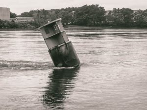
Buoy number 13 marking the Picataqua’s channel bows to the river’s powerful currents. Here brackish water ebbing tips it toward the sea from whence the water came. – Judy Schneider photo
The half tide currents between the two reach four to five knots. In contrast our twice-as-long Ipswich River has only one fifth the watershed area and relatively slow currents. The rivers in our arc of the Gulf of Maine from Cape Ann to Kittery, the Ipswich, Parker, Merrimack, Hampton, and Piscataqua, are very different rivers.
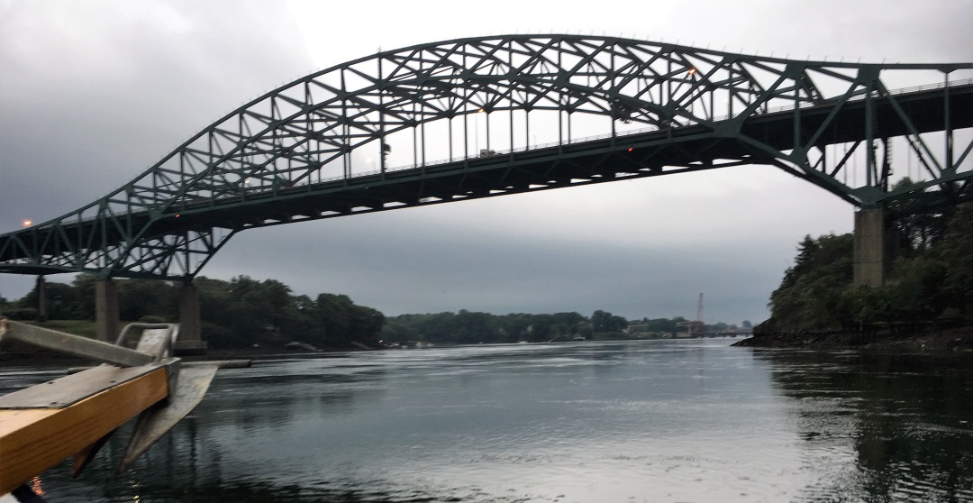
Last week on their annual outing about forty Middleton Stream Teamers and friends took an early evening cruise from downtown Portsmouth up the ebbing Piscataqua into Great Bay and back. The large engines of the 50 foot long Portsmouth Harbor Cruise vessel labored against the strong current. It took one and one-half hours for the 12 miles up from the start and only forty five minutes to return. The fast moving water roiled around the huge columns supporting routes 1 and 95 bridges. In the days of oars and sails, boat and ship movements were done on slack or favorable tides. The Old Closeteer remembers rowing races in dories in the Portsmouth harbor area. Two strong young men trying to buck the ebb and flood currents at peak flows with oars stood still and soon fell off and went with the flow. Races were planned for slack lows or highs.
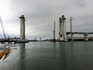
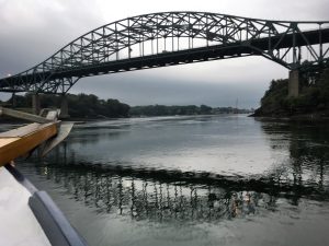
The impressive bridge towers of routes 1 and 1 A further east are being rebuilt. Portsmouth is seen to the right. The once infamous white U. S. Naval prison in Kittery can be seen in the background. – Elaine Gauthier photo
Despite the currents, deep water in the narrows between Portsmouth and Kittery has made this a busy and well known Atlantic seaport since the early 1600s. For a century before that fishermen from the “Old World” in small ships no doubt used it when here fishing spring to fall. We know they had fishing stations on the Isles of Shoals just six miles to the east off shore. The half-dozen granite islands’ early English name was Smythe Isles, so dubbed for warrior, entrepreneur, and explorer John Smith.
His and subsequent fishing stations in the area were among astoundingly rich waters, thick with fish, nourished by the Piscataqua River and 6000 acre Great Bay and its six feeding rivers. The cruise took the group up into the shallow, much warmer, bay where about half its area is exposed mud flat at low tide. The captain cited marine studies done there to bring the oysters and anadromous fish back. The oysters are still there, and herring return to the bay’s rivers each spring to spawn. Their numbers, however, don’t compare to early colonial days and before, when for ten millennia natives occupied the coastal lands and waters. Beneath the water at half tide, unseen to the visitors, are eel grass meadows, nurseries for many species who feed fish well out into the Gulf of Maine. The cruise ship passed patches of floating eel grass the currents that had torn loose and were en route to sea where they too would become food. Great Bay is said to be the second largest inland estuary along the east coast of the country that is not directly connected to the sea. The boat passed by UNH’s Jackson Lab where marine life is studied and oysters resistant to a devastating virus up from the Chesapeake Bay are being developed. Stream Teamer Fran Masse and his oystering buddies, who raked the Eagle River in Ipswich, used to bring empty shells to Jackson Lab for use as substrate. After a composing period in quarantine shells are sprinkled in the bay for planktonic oyster larvae to attach to. The tiny “spat” need hard surfaces as lifelong anchors.
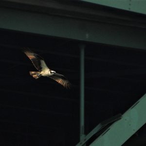
This osprey flies under a 24-7 stream of cars above on route I-95. – Donna Bambury photo
An encouraging sign indicating healthy bay habitats are the stands of mature trees almost completely fringing the uplands surrounding Great Bay. The bay’s habitats in order of decreasing area are underwater meadows of eel grass, mud flats, salt marshes, channel bottoms, and rocky intertidal edges. The pastures and sawmills that once ringed the bay are long gone gone. Manure and sawdust no longer run off during rains and spring melt. The trees and ground cover catch sediment; the water is infiltrated among billions of soil organisms and a labyrinth of roots. Ground and runoff water is thus cleaned. The bay is now protected by law from the discharge of sewage and industrial wastes throughout the watershed. The cities of Dover and Rochester in the headwaters of the Piscataqua, once important mill towns, are now quiet.
Mighty route I-95’s current flows on asphalt from Maine to Florida. In the river below its bridge across the Piscataqua the current shifts direction four times a day. – Elaine Gauthier photo
The bridges crossing the Piscataqua from New Hampshire are not quiet. Traffic on mighty I-95 never ceases. Routes 1 and 1A bridges are being rebuilt. One of the highlights of the cruise was hearing from recently retired marine heavy equipment operator and Stream Team member, Leon Rubchinuk, talk about his work removing and repairing old bridges over the river. For 27 years he worked from piers and barges, Texas to Maine, taking down and raising structures above and below the water. As we passed under the new bridges Leon vividly described what has been done to make way for the new and what is happening now in and above the currents as the structures are built.
While riding the ebb back under the bridges the Old Closeteer thought about tidbits of Portsmouth’s dynamic history, a place very important in our country’s early trade and later wars. John Paul Jones supervised the building of the new nation’s frigate Ranger in Portsmouth from 1781 to 1782. Privateers pestered and profited from British shipping in the War of 1812. In the 20th century submarines were built and repaired for the world wars. The work goes on. The Closeteer remembers when he was six in 1939 listening with his parents to the radio as the fatally crippled SS Squalus and crew, down over 200 feet outside the harbor, were being rescued. Twenty six not taken to the surface in a recently invented Momsen diving bell perished. As a child during WWII, the Closeteer remembers hearing strange rumblings in the wee hours of the night. Stories next day back from the shipyard were that a U-boat had been sunk by depth charges just off the coast as it attempted to approach the outer harbor. The State Park in Salisbury was then an Army Anti Aircraft battery to protect the Portsmouth Shipyard twenty miles to the north. Portsmouth’s most famous international event was the peace treaty between the Russians and Japanese in 1906 arranged by President Theodore Roosevelt. The negotiations successively proceeded under his supervision from Washington.
The news from modern Washington, hurricane Harvey in Texas, impending arrival of Irma, and Korea was remembered by the Closeteer upon the cruise’s return to lovely downtown Portsmouth. He was somewhat reluctant to end the trip and go ashore. It had been an interesting escape into the past, dreaming of days gone by and hearing of improvements in the water of Great Bay and the Piscataqua, which no longer stinks as rivers often did when he was a child.
___________________________________________________________
WATER RESOURCE AND CONSERVATION INFORMATION
FOR MIDDLETON, BOXFORD AND TOPSFIELD
| Precipitation Data* for Month of: | June | July | Aug | Sept | |
| 30 Year Normal (1981 – 2010) Inches | 3.95 | 3.89 | 3.37 | 3.77 | |
| 2017 Central Watershed Actual | 6.08 | 3.43 | 1.22 | 2.4 as of Sept 15 | |
Ipswich R. Flow Rate (S. Middleton USGS Gage) in Cubic Feet/ Second (CFS):
For Sept 15, 2017 Normal . . . 4.2 CFS Current Rate . . . 1.74 CFS
——————————————————————–
*Danvers Water Filtration Plant, Lake Street, Middleton is the source for actual precipitation data thru Aug.
** Middleton Stream Team is the source of actual precipitation data for Sept..
Normals data is from the National Climatic Data Center.
THE WATER CLOSET is provided by the Middleton Stream Team: www.middletonstreamteam.org or <MSTMiddletonMA@gmail.com>