Water Closet for November 10, 2017
[pullquote]”Natural music from the brook, wind in the trees, and rain drops pattering on leaves and clothes accompanied the hikers.”[/pullquote] After three months with little rain five inches fell here in the last week of October. The Ipswich River rose a foot bringing it up to average depth and flow for this time of year. Water in its tributaries has resumed. Middleton Stream Teamers and guests recently visited a brook little known except to cows that drink there May to October. Stream Teamers call this lovely stream down from Boxford “Pond Meadow Pond Brook” a name used by the late Middleton game warden Chester Masse. His son Francis passed the name along to friends. The pond labeled on the USGS map as Pout Pond was “Pond Meadow Pond” to Chester. Pout Pond was too common a name on our Yankee maps for him. Two ponds so named on the federal map in Middleton are just two of thousands of ponds where horn pout are caught. The mystery becomes, where is the other pond in the sequence, pond-meadow-pond? In the last two decades, after a three century hiatus, beavers have come back giving us an argument to justify the name. The brook’s headwaters in Boxford State Forest include a huge beaver impoundment (“pond”) above a large dam just north of the Middleton line. Its overflow moves south a quarter mile to a kettle pond Chester called Pond Meadow Pond, which is now the deep part of a very large beaver impoundment (another “pond”) behind a 200 foot long dam with a 6 foot head at the north end of “Second Pasture” off North Liberty Street. Its overflow continues as Pond Meadow Pond Brook two miles south to Boston Brook a major tributary of the Ipswich River. In farming days many of our cleared red maple swamps were meadows for pasture or hay so change pond meadow pond to “impoundment-meadow-impoundment.” It is too bad the English ignored the Naumkeag names which were descriptive. The Indians had beavers as we do again so maybe the name translated from Algonquian might have been impoundment-meadow-impoundment but with a better sound.
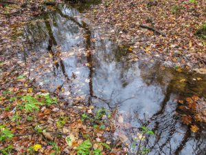
Ground is receiving fall leaves from the maples above; their trunks and branches are reflected in the brook. – Judy Schneider photo
Well that’s all water over the dam; let’s return to the Stream Team’s recent hike up the Pond Meadow Brook Valley. Notice a Pond missing in the name. When Stream Team sign maker Francis Masse routed the brook’s name on a vertical signpost he ran out of space so omitted the second pond. Sorry but we don’t seem able to get away from name calling. Our nation’s capital is having that problem now.
The only problem the fall walkers had was warm rain and a Patriots game which cut down on attendance. They started at Mundy Bridge, now culverts, through which Boston Brook down from Andover flows into Prichard Pond. Charles Prichard, Joan Cudhea’s grandfather, in the early 20th century built a dam one-third mile downstream and voila he had a “pleasure pond” for his family. Ooops, more names again, this one from an early 20th century Essex County dam inspector who had to call it something; since it didn’t power a mill he did the best he could with “pleasure.”
Mundy Bridge, where 20 started the hike in a gentle rain also needs explanation. The old Closeteer used to think it was simply a place where washing was once done on Monday the traditional wash day of old. Monday was somehow corrupted to Mundy. The stone rapids falling to North Liberty Street seemed perfect for washing and wringing out clothes in clear fast moving water. Stream Teamer Red Caulfield tells the story of a woman who weekly walked a half mile there to launder her family’s clothes. There must have been many since colonial times and up until washing machines. Alas, in an old deed Mundy in Mundy Bridge is for a lady who lived nearby and perhaps long ago owned the land.
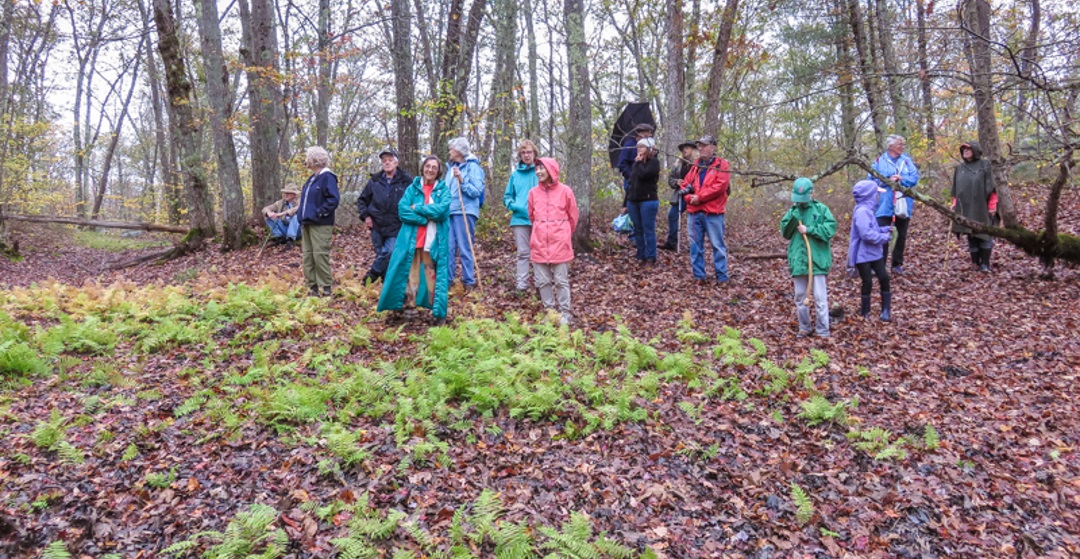
The fall walkers left their road machines, and after instructions from Stream Team President Sandy Rubchinuk about things to look for during the hike, got underway. The directions resembled those for a children’s treasure hunt but even the old timers wanted to play. The hike leaders couldn’t keep grandparents from participating and giving the kids hints.
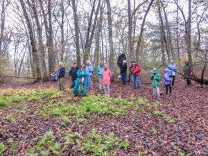
Stream Team fall hikers gather in a mysterious basin some think was made by meteor because of its shape and different stone found in its center. In the spring it will be full of water. – Judy Schneider photo
The group crossed the steel bridge over Pond Meadow Brook where it enters Prichards Pond. Beneath its upstream edge was the first of four beaver dams between Prichards Pond and Boxford. Fukiko Cudhea, a Japanese woman, co-owner of Prichard Pond and surrounds stepped off the gravel driveway to the Prichard-Cudhea cottage on to a rocky path beside the turbulent brook. The hikers followed. She had made the rough but pretty path for family, passers by and guests. It is very Japanese with running water, stones, mosses, ferns and pleasant shade. After walking the path the hikers turned north up the brook’s valley on a skidder trail which after just six years since selective logging is green with flowering plants.
Off the skidder road where logs were dragged by a huge machine, they bushwhacked along the brook in forested floodplain. To their east rose exposed ledge and thousands of stones cracked off it by ice for 12,000 winters since and before when the continental glaciers passed our way and later melted. Along the brook stand the corpses of red maples drowned since the beavers returned two decades ago and raised the water. The land between ledge and swamp is graced by handsome white and red oaks and a few big white pines. Outlining onetime farm parcels are 200 year old lichen-painted stone walls. You are urged to get off our roads and enter mature woods which were once rough pastures. We are blessed with many in the area. The feeling among these now relatively undisturbed places soothes the soul. Trees have taken over; their fallen leaves are thickening and softening the living soil. The walls and plants, farmers and livestock long gone, are fine habitats for fellow creatures here long before humans. Natural music from the brook, wind in the trees, and rain drops pattering on leaves and clothes accompanied the hikers.
Rain sounds comforted us upon entering Richardson’s “First Pasture.” The cows were gone for winter. Their pasture beside the stream, surrounded by oaks just turning color and hickories bright yellow, was beautiful even under a gray sky.
The hikers turned away from the brook; and like two woodland fires there in the last decade moved on eastward. The fires had killed small and sick trees. The woods of fire culled mature hardwoods and occasional pines, their canopies above waist-high huckleberries, were open and very pleasing to the eye. The trunks of thin barked young pines done in by the fires lay chris-crossed on the forest floor.
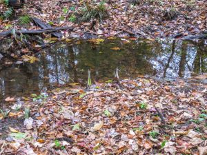
Pond Meadow Brook in north Middleton. This year’s warm October has fooled many plants into blooming. Here skunk cabbages are seen peeping forth. A thermometer was inserted into one where the temperature was 4 degrees Celsius higher then the water in the stream. – Judy Schneider photo
The oak canopy above, already thinned by wind and rain, became even sparser as the walkers moved into a large circular area eaten by gypsy moth caterpillars these past two late springs and early summers. The 2016 infestation affected about ten acres. In 2017 the caterpillars moved out to take in eighty more. Brown oval patches of egg masses were found on the bases of many tree trunks. If a certain virus and fungus don’t kill the eggs or caterpillars next year’s affected areas may be much larger.
The hikers turned south at a woodland crossroads and left the gypsy moth changes for another kind left by man. What seemed a great mess in the winter of 2011-2012 left by loggers after departure is now oak sprout land up from the acorns exposed to light when parent trees were taken down over a dozen acres. The logger left a few trees in this clear-cut to provide seed. The thousands of young oaks racing for the sky and light are now six to twelve feet tall. It reminds one of the start of a marathon when 1000s of runners are crowded together. In trees such density makes for tall straight trunks, the kind the New England Forestry Foundation people will like to see when they return decades hence to harvest from the land under their care again. In the past few years berries have thrived in the clearings between the sprouts.
Stream Teamers and other hikers will return yearly to marvel at the changes. From a wildlife point of view it is not about human names overdone above, but rather habitat edges. The walkers saw a dozen edges in just two hours. They were: pond-woods, beaver impoundments-woods, pasture-woods, burned woods-unburned, wetlands-uplands, clear cut-selective cuts, stream-pasture, stream channel-floodplain, gypsy moth affected-unaffected. Within each one these ecosystems are more subtle edges and resulting diversity. It seems wildlife and some people thrive on the edge.
_________________________________________________________
WATER RESOURCE AND CONSERVATION INFORMATION
FOR MIDDLETON, BOXFORD AND TOPSFIELD
| Precipitation Data* for Month of: | July | Aug | Sept | Oct | |
| 30 Year Normal (1981 – 2010) Inches | 3.89 | 3.37 | 3.77 | 4.40 | |
| 2017 Central Watershed Actual | 3.43 | 1.22 | 2.44 | 5.8 | |
Ipswich R. Flow Rate (S. Middleton USGS Gage) in Cubic Feet/ Second (CFS):
For Oct 27, 2017 Normal . . . 23 CFS Current Rate . . .59.2 CFS
—————————————————————–
*Danvers Water Filtration Plant, Lake Street, Middleton is the source for actual precipitation data thru Sept.
** Middleton Stream Team is the source of actual precipitation data for Oct…
Normals data is from the National Climatic Data Center.
THE WATER CLOSET is provided by the Middleton Stream Team: www.middletonstreamteam.org or <MSTMiddletonMA@gmail.com>