
Water Closet for August 22, 2014
IT ALL FLOWS DOWNHILL (PART II)
by Arthur McKee1
(Ecologist McKee’s Part I of this essay ended here last week after listing some of the many successes arising from the Clean Water Act. Here in part II he resumes.)
There are some recent trends, however, that have the potential to reverse these improvements that protect our water from polluted runoff. Not as dramatically as phosphorous laden agricultural runoff, but are practices which can increase sediment and nutrient loads, and decrease quality of aquatic habitat. [pullquote]”Roadside vegetation is not just being mowed; it is being eliminated by herbicides or grading”[/pullquote]These are most conspicuous in rural areas and involve management of roadsides and ditches. Urban watersheds have their own set of problems associated with storm drainage off hard surfaces where pollutants have accumulated and are easily washed into the storm drains.2
But back to roads in rural areas. Watershed studies at research stations such as the Andrews Experimental Forest in the Oregon Cascades have revealed that poorly designed and maintained roads are disproportionably responsible for stream sediment and nutrient loading when compared to logged areas. While fewer studies are available for agricultural watersheds with crops and fields, it’s clear that when conservation farming techniques are used such as contour plowing and crop rotations the results are similar.
Poor road design includes unstable roadbeds on loose, easily erodible fill and undersized culverts that cannot handle large storm flows, which cause the ditches to overflow the road and wash out the road’s shoulders and base. Management that eliminates vegetation along edges and in ditches makes roads very easily erodible by eliminating the leaf cover that reduces the splash energy of rain and the roots which hold the soil together and provide rooting strength that resists erosion.
Highway engineers are increasingly aware of the need to design roads to handle the once-in-50-year storms. The costs of reconstruction and repair argue persuasively for up-front prevention, and road failures are largely the result of old designs. But, for various reasons, highway engineers and those responsible for highway maintenance are taking a scorched-earth policy to roadsides and ditches. Roadside vegetation is not just being mowed; it is being eliminated by herbicides or grading. In part this is due to safety issues such as maintaining good sight distances on curves and eliminating trees close to the road. In some parts of the country, it is due to considerations of eliminating noxious weeds or undesirable plant species that could lower the value of the crops being grown next to roads (read agricultural lobby). In other cases, it seems to be a simple consideration of wanting the roadsides to appear “neat” and unmowed shoulders are not as “neat” as bare earth in some aesthetics.3
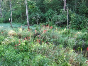
Lush vegetation flanks Boston Brook’s channel. On the upland above the brook’s floodplain are bushes and trees. Large houses are being built above this scene 200 feet away. Runoff from its roofs, lawns, driveways and road will be filtered by the root filled living soil also home of fungi, bacteria, insects, worms and many other organisms. The water making it to the ground water and eventually the brook will be well filtered. One hundred years ago cattle grazed down to our brooks and waded in them. Vegetated buffers are essential to the health of all water bodies. – Middleton Stream photo
Whatever the reasons, it is increasingly common to see bare verges (edges) and ditches along roads. During storms, the ditches quickly fill with runoff that is heavy with sediment, and in the case of northern New England with salt from the winter’s sanding and salting. With no vegetation to slow the runoff and trap the sediments they are moved quickly into the streams. The ability of water to do work increases with the cube of its velocity, so that very small changes in how swiftly the ditchwater is flowing means big increases in sediment loads. It also means reduced time to trap the nutrients being transported and sequester them into the soil and vegetation.
There is a potential consequence of rapid runoff in northern New England where deep snowpacks can accumulate. Like all precipitation in the Northeastern US, snow contains acid from automobile exhausts and power plant emissions up wind. That acid can be rapidly released during snowmelt, and seep into soil that is already acidic. One form of elemental aluminum (Al) goes from nearly insoluble to very soluble over a tiny change in acidity of soil water and is swept along into ditches and streams. In the immediate vicinity of a fish’s gills, it can and will come out of solution and precipitate onto the gill’s surface blocking off the oxygen in the water to the fish. The fish is effectively being choked and has to beat its heart faster to breath. That extra energy cost can use up its reserves and it can starve. The emaciated looking fish sometimes caught in New England waters in the spring is the result of this Al coating its gills. Whatever speeds water from snowmelt into streams ups the probability of fish being harmed this way.
Finally, in the hilly countryside of Vermont, many of the roads parallel streams, and many of these are being widened for safety considerations. I noticed that often the widening was accomplished by encroaching on the stream, narrowing the channel and/or floodplain. This sets the stage for the infrequent but big storms to wreak havoc, especially if the rip-rap armoring the roadside is undersized, and that seemed to be the case with every such widening I drove past.
The overall message above is a good-news/bad-news story, and an ever shifting one as society changes various agricultural and other management practices along with environmental regulations in the face of climate change. The knowledge exists to better inform environmental decisions at all levels, but societal attitudes and politics makes that an inefficient process.
1 Arthur McKee is Director Emeritus H. J. Andrews Experimental Station in the Oregon Cascades. His specialty is forest ecology. McKee provided the Water Closet with four well received essays in the past year. This, his latest submission, was divided into two parts. The above is Part II.
2 Middleton’s new storm water management bylaw approved at May 2014 town meeting will go into effect next month. (Stream Team note.)
3 “Neatness” to environmentalists is a problem from manicured, chemical doused lawns to wide granite curbed roads. The best buffer between our roads-lawns and wetlands are places with dense vegetation including much maligned plants called “weeds”. Boxford habitats enjoy “country drainage” along roads without creature blocking curbs, just natural vegetated swales that collect and filter runoff. (Stream Team note.)
__________________________________________________________________________
WATER RESOURCE AND CONSERVATION INFORMATION
FOR MIDDLETON, BOXFORD AND TOPSFIELD
| Precipitation Data* for Month of: | May | June | July | Aug | |
| 30 Year Normal (1981 – 2010) Inches | 4.06 | 3.95 | 3.89 | 3.37 | |
| 2013 – 14 Central Watershed Actual | 2.77 | 2.03 | 7.26 | 2.8 as of 8/19** | |
Ipswich R. Flow Rate(S. Middleton USGS Gage) in Cubic Feet/ Second (CFS):
For Aug 19, 2014 Normal . . . 6.1 CFS Current Rate . . . 11 CFS
*Danvers Water Filtration Plant, Lake Street, Middleton is the source for actual precipitation data thru July. Normalsdata is from the National Climatic Data Center.
**Updated Aug precipitation data is from MST gage.
THE WATER CLOSET is provided by the Middleton Stream Team: www.middletonstreamteam.org or <MSTMiddletonMA@gmail.com> or (978) 777-4584