Water Closet for March 16, 2018
The TV weather folks had warned us for a week that a storm was heading our way from the southwest with impending complications coming up the East Coast and down from the Canadian Shield. Thursday evening, March 2, an east wind strengthened under a cloud-covered full moon pulling on the water. With the promised nor’easter, it looked as if the beaches and marshes were in for a wild old time. By midnight gale force winds had the ocean waves high and the trees inland roaring in excitement. Over two inches of rain came in at a blizzard’s slant. Despite the noise, the old Closeteer slept. He’d go out Friday afternoon when the wind was supposed to reach a crescendo endangering trees, power lines, and barrier beaches.
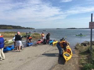
Middleton Stream Teamers and friends prepare to cross the flooded Essex-Ipswich salt marsh on astronomical high-runner-tide. This photo was on a summer day without a storm. In your imagination add a couple more feet and waves to picture a nor’easter such as that on March 2 and 3, 2018. – Elaine Gauthier photo
Many trees and lines on the Cape went down. Countless hundreds of tons of sand were swept out from the beaches to join the offshore bars. Waves also carried sand into the center of Salisbury Beach. A third of a million-people on the South Shore and Cape lost electricity. The salt marshes and causeways to barrier beaches on the North Shore were covered for hours with seawater during the storm’s three full moon highs at midday and midnight. On Saturday afternoon as the storm continued the old Closeteer and Rings Island friend visited Plum Island three hours after high tide. The marshes were still covered. A sustained gale out of the northeast had shoulder high waves on the Merrimack’s mouth dancing, showing white petticoats. Water Street along the Merrimack’s Newburyport shore was wave-wet and flanked by windrows of drift cord grass from the banks of the rivers and cricks that had been pushed off the street by city plows. After crossing the flooded salt marshes which appeared a broad sea from the causeway the visitors arrived at the barrier beach called Plum Island. The ominous low roar just over the dunes of the Atlantic drew them on. The Parker River Wildlife Refuge gate was closed. A side street east got them behind the infamous houses in jeopardy on the high dunes above the beach. They parked their car and with a couple other curious souls climbed a dune eastward into the wind. Upon reaching the top the nor’easter hit them hard. The beach and usual ocean scenes were gone. A half-mile band of roiling white caps coalescing came into view right up to the foot of the dunes. It stretched as far as they could see both north and south. Out beyond the noisy chaos was the leaden gray-blue sea striped with the breaking crests of in-coming swells. There would be no real low tide in three more hours as shown on the tide chart.
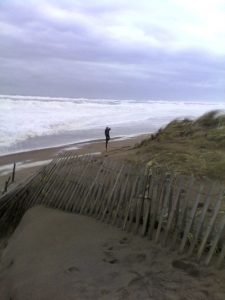
Saturday, March 3: This photograph of wide band of surf three hours after high tide at Plum Island was taken with a cell phone held in gale force gusts. The man on the beach is standing above the ocean’s usual high-runner-tide (king tide) elevation. The strong nor’easter raised the swells well above the astronomical high usually following a full moon. The beach front houses in the area are in jeopardy. Unwise past attempts to save others here have failed. – Nancy Sander photo
The Rings Islander asked a young Plum Islander if he’d seen the surf like this before. He, a surfer, said he had not. Across the river at midnight and midday her Rings Island had become a true island as the wind-exacerbated tide flowed over the roads across the salt marsh to Salisbury’s once fishing village. For a while the town blocked off the flooded roads. Climatologists predict by the end of the century that a foot to ten feet of higher water from melting Greenland and Antarctica ice may make our coastal hills islands. You’ll need a boat to get to Old Town Hill in Newbury and Castle Hill in Ipswich. A good part of Boston built on past fill may be under or protected by levees. See old maps of our Colonial capital.
While standing on the narrow edge of the storm ravaged beach the Closeteer thought again as he had three-quarters of a century ago as boy when he helped an old Salisbury carpenter patch up Plum Island ocean front houses after a couple nor’easters. During one a couple cottages nearby had fallen in and gone out to sea. Nancy Weare’s fine book, Plum Island: The Way It Was, shows maps of where the river used to be as it entered the sea before the late 19th century jetties. Before them the river’s mouth used to wander north and south. The Closeteer as a boy was struck by how vulnerable the cottage covered barrier beach seemed. Last Saturday standing where houses have gone in this past decade he was surprised by folks’ folly once again. Even if the ocean’s elevation rose a couple feet Plum Island, Salisbury Beach, Seabrook Beach, and Hampton Beach would become off shore bars and the salt marshes behind them would erode away.
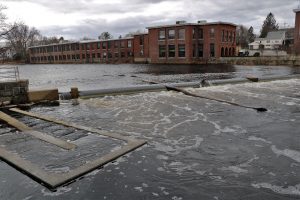
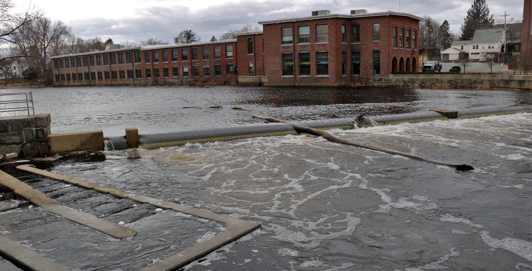
Dam in Downtown Ipswich at height of storm. Dam top is usually several higher than tidal water below. The astronomical high and nor’easter winds filled the tidal side to the brim. Fish ladder, topped-off, is on the left. – Elaine Gauthier
The vast ocean when so ruffled at its edges warns and frightens but it doesn’t keep some folks from building just above high water. The Closeteer recommends William Sargent’s 2015 book PLUM ISLAND: 4000 Thousand Years a Barrier Beach. Sargent in an entertaining and at times disgusted way tells the history of the barrier beach we love. He pungently chronicles the shenanigans of the last two centuries by people and their governments’ attempts at taming Mother Nature. The Fed’s protections came too late mid-last century. They’ve done a good job for all including wildlife and plants on the southern two-thirds. After future storms when the road barriers have been taken away visit to see what ever higher waves have done. The old Closeteer bets on Mother Nature down the stretch. She won’t allow houses for a few short-sighted people to remain on her protective barriers.
___________________________________________________________
WATER RESOURCE AND CONSERVATION INFORMATION
FOR MIDDLETON, BOXFORD AND TOPSFIELD
| Precipitation Data* for Month of: | Dec | Jan | Feb | March | |
| 30 Year Normal (1981 – 2010) Inches | 4.12 | 3.40 | 3.25 | 4.65 | |
| 2017 Central Watershed Actual | 2.97 | 4.04 | 3.76 | 4.1 | |
Ipswich R. Flow Rate (S. Middleton USGS Gage) in Cubic Feet/ Second (CFS):
For March 9, 2018 Normal . . . 112 CFS Current Rate . . .268 CFS
*Danvers Water Filtration Plant, Lake Street, Middleton is the source for actual precipitation data thru Feb..——————————————————————–
** Middleton Stream Team is the source of actual precipitation data for March.
Normals data is from the National Climatic Data Center.
THE WATER CLOSET is provided by the Middleton Stream Team: www.middletonstreamteam.org or <MSTMiddletonMA@gmail.com>