Water Closet for February 2, 2018
The old Closeteer has lived near the coast of the Gulf of Maine for three quarters of a century. His playground as a boy and now when clamming is where the continent meshes with the ocean. He experienced this wondrous interface as a boy on the salt marshes and barrier beaches at ground and water level and later learned of their importance. In mid life he wrote
Dark and light green grasses
In cowlicks swirl ‘tween soft marsh cricks
Levied by dune and upland rock
Watering place for more than ducks,
Has depth and breadth
Beyond its bounds.
Where larval travelers get their start
And subtler cycles turn
To nourish out a thousand miles
In November Melissa Paly of the Great Bay – Piscataqua Waterkeeper – flew in a small plane over the estuaries in New Hampshire, a continuation of ours. She returned and wrote the following which she has kindly given the Water Closet permission to use.
Reflections on the water – the birds eye view By Melissa Paly
In late October an unusual email landed in my Waterkeeper inbox. A group named Light Hawk, experienced pilots who like to fly for a purpose, asked if I’d be interested in taking a plane ride over the Great Bay – Piscataqua region right when the tide was going to be at one of its highest heights in 2017. Who says “no” to an offer for a free ride in a small plane?
So on a sunny Saturday morning in November, I pulled into Port City Air at the Pease tradeport and met Bob Ferber, a pilot with 30 years of flying experience, who’d come all the way from Utica, New York, to take me up for a bird’s-eye view of “my” watershed. At the same time, other LigthHawk pilots were taking waterkeepers aloft over bays and estuaries from Maine to Maryland to see how an unusually high tide – a proxy for sea level rise – will impact our coastal communities.
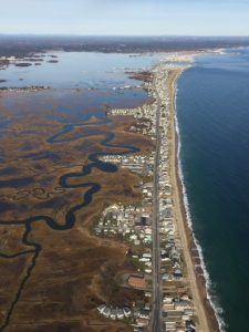
Heavily developed barrier beaches of Seabrook and Hampton, New Hampshire, flanked by ocean and grass-capped salt marsh of soft peat. This photo was taken at “a high runner” or “king” tide when the Moon, Earth, and Sun are in line. These parallel habitats stretching from Portland to Cape Anne beneath bird migration flyway are at very similar elevations, hence vulnerable as the ocean rises. Plum Island has been losing houses to the sea for decades. The marshes may join the ocean this century. – Melissa Paly photo
Once we were strapped in and prepped on the do’s and don’ts of being in a small plane, we took off from the Pease runway and gained altitude over Newington, passed over Fox Point and headed to Durham, where familiar landmarks like UNH’s Whittemore Center and football stadium helped me geo-locate. From this vantage looking east, the blue ribbon of the Oyster River at the far end of town T-ed into Little Bay, a wooded landscape wrapped the main lobe of Great Bay out the right window, and the straight stretch of the Piscataqua cut a quick gash to the open ocean.
We banked northeast from Durham and flew over Dover, its mill complex straddling the Bellamy River. I was fascinated to see how tightly the Spaulding Turnpike hems in the narrow channel, the highway with its severe angles butted up against the river’s sinuous meanders.
We headed east from Dover over the Cocheco River toward South Berwick, Maine. A carpet of green farm fields and golf courses was laced by ochre woods that still held their late autumn leaves. I could read the V where the two Maine rivers – the Salmon Falls and Great Works – join forces and become the main stem of the Piscataqua.
Bob gently banked as we followed the Piscataqua south, the Eliot neighborhoods on the Maine side, the industrial stacks of Sprague, Schiller and Newington stations on the other. The three bridges shone like thin strands of a spider’s web, oblivious to the state border they spanned.
In short order we were over the industrial complex of Portsmouth Naval Shipyard, Bob taking great care to keep the air traffic controller fully apprised of our flight plan. I wanted to get a peek over my hometown so we tacked northeast over lushly wooded Spruce Creek in Kittery, Maine. The landscape I know so well from sea level – Fort McClary, Pepperell Cove, Wood Island, Chauncey Creek, Fort Foster – sparkled from 1,000 feet.
We flew northeast as far as the York River and then turned back toward points south. I wanted to be sure we achieved our mission for the flight – to look at the Seacoast’s most vulnerable coastal areas at the height of the King Tide. As much as the whole flight so far had been spectacular, it was this stretch of the trip that really took my breath away.
If you’ve driven along Route 1A through Rye, North Hampton, Hampton and Seabrook, you know there are expansive marshes on one side, beaches on the other. But when you fly over – at a monster tide – you see that the ribbon of road barely rises above either one. With the marsh flooded like an overflowing bathtub and the surf making the beaches all but invisible, it was startling to see how tenuous the hold is on the roads and neighborhoods in between.
I found myself momentarily lost in the mottled blues and browns of the Hampton-Seabrook Marsh, mesmerized by the abstract patterns of the inundated channels. But something else was welling up besides an artistic appreciation of shape and color – it was a sense of wonder that people had the audacity to build communities where the water so obviously owned, and a sadness that the water may well own it again in the decades ahead.
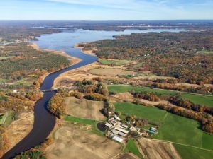
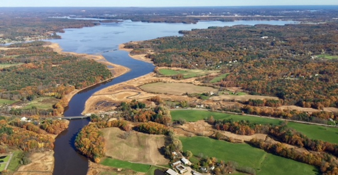
Fresh waters via several tributary rivers enter the tidal water of the Piscataqua River and Great Bay to nourish organisms in the Gulf of Maine and beyond. – Melissa Paly photo
Bob pulled me out of my reverie to talk flight plan. We banked west, headed inland over the problematic Coakley landfill in North Hampton and Greenland, then over the squiggling course of the Winnicut River as it meets Great Bay. We banked over neat subdivisions in Stratham, over farms and woods along the Squamscott, and up the Lamprey to where its tidal reach is blocked by the McCallen Dam that long powered Newmarket’s textile mills. Different town, different river, I thought – but how similar it is to other ends of the system. The rivers of this Great Bay – Piscataqua watershed have been the lifeblood of our communities for centuries.
On our final leg of the flight, we headed over Durham and the jutting peninsula of Adams Point, across to the Newington shore where the Pease airstrip lay in the near distance. I looked down at a distinctly two-toned canvas – a dark blue of deeper water sharply demarcated against a silty, milky brown along the shore. It was a sudden reminder that the system’s vulnerability – its shallow water, swift currents, convoluted geography, many communities and land uses – was painted right on the surface. The land feeds the water, for better and for worse.
Bob eased us back down to Port City’s airstrip. Before stepping out of his Cessna, I took a moment to soak it all in. I was so struck by how it was the water – not the land – that had dominated the view from up there. The waving arms of the rivers, the octopus-body of the bays, the soft-hued marshes and pale blue horizon of the open ocean – they created the structure of what we think of as home. Our houses, schools, offices, industries, shopping malls, roads and bridges – we have just squeezed all that onto a little solid ground between aqueous arteries. How fitting, I chuckled with Bob, that we call ourselves – not the Sealand – but the Seacoast.
For updates, events and musings, please join the Waterkeeper’s Facebook Group “Save the Great Bay – Piscataqua Estuary.” Melissa Paly can be reached at mpaly@clf.org.
Melissa Paly is the Great Bay – Piscataqua Waterkeeper.
__________________________________________________________
WATER RESOURCE AND CONSERVATION INFORMATION
FOR MIDDLETON, BOXFORD AND TOPSFIELD
| Precipitation Data* for Month of: | Oct | Nov | Dec | Jan | |
| 30 Year Normal (1981 – 2010) Inches | 4.44 | 4.55 | 4.12 | 3.40 | |
| 2017 Central Watershed Actual | 4.03 | 1.54 | 2.97 | 4.9 | |
Ipswich R. Flow Rate (S. Middleton USGS Gage) in Cubic Feet/ Second (CFS):
For Jan 26, 2018 Normal . . . 59 CFS Current Rate . . .75.6 CFS
——————————————————————
*Danvers Water Filtration Plant, Lake Street, Middleton is the source for actual precipitation data thru Dec..
** Middleton Stream Team is the source of actual precipitation data for Jan.
Normals data is from the National Climatic Data Center.
THE WATER CLOSET is provided by the Middleton Stream Team: www.middletonstreamteam.org or <MSTMiddletonMA@gmail.com>