Water Closet for May 16, 2014
Middleton has an interesting valley stretching one-half mile west to east between East and Locust streets. In its draw a brook runs over clean sand easterly through a red maple swamp now resplendent in opening skunk cabbages. [pullquote]”beavers fascinate as they create rich new habitat called “beaver meadows” and destroy stands of favorite trees”[/pullquote]Gently climbing above the brook’s wetland to the north the land levels out into a terrace of well drained alluvial soil supporting a mature stand of pitch pines. To the south, a drumlin more steeply rises to the heights of the County Jail and MIT’s Bates Laboratory on Bare Hill. Bare Hill is a “wet hill” with perched water tables; it does not have well drained soils. Helped by year round moisture, a fine mature forest of mixed hardwoods has grown from what was pasture 70 years ago. Forty-four acres of slope, wetland and stream are now town land with shady trails open to the public.

Why are the beavers making so many deep notches, so close, in this yellow birch they felled? Some say it will be a totem pole, others a practice gnawing log for the young, and one thinks it is the work of a crazy beaver sculptor.
– Judy Schneider photo
Stream Teamers, Glenice Kelley and photographer Judy Schneider, visited the five year old beaver impoundment there last week and found a fallen, long yellow birch log strangely gnawed into what they dubbed the “auger”. Over the last nineteen years since the beavers returned we have found hundreds of beaver carvings. These are usually logs cut to handling size. The “auger” is of deep notches every few inches in a foot diameter log. It reminded one visitor of a totem pole in the works. Did the beavers somehow plan to raise it or seek people help? Another thought it the work of a gnawing class of young beavers. Professor beaver stood on a tiny mound nearby and instructed his enthusiastic students. Another guessed the sculpture might be the work of a disturbed beaver, perhaps like Vincent van Gogh who in his last years worked fast and wildly with magnificent results. We humans not versed in beaver art were interested in what we saw yet may not have been able to fully appreciate its artistic qualities. Perhaps the next generation of creative beavers will see the light and praise the new Locust-East Valley School. After all it took a while for art critics to catch on to the luminous works of the Hudson River School.
Let’s leave the sculpture and return to the pleasant valley, our subject. We can’t leave the beavers because they with a 250-foot long, 3-foot high, dam have drastically changed the floodplain as have their dams in so many places. Webber’s Pond, about a 100 by 200 feet rectangle, just below East Street has graced this picturesque street for as long as we old timers can remember. In the summer its shallow water puts on a grand white water lily show. The other day an old Closeteer and grandson passing spotted a great egret on its edge swallowing a sun fish. Ducks as well are herons are admired there. Old United States Geologic Survey maps show overflow from the pond in a stream going west toward the nearby Ipswich River. Since people did something to the culverts under East Street, we don’t know when, overflow and runoff from the pond and flanking hills seem to flow eastward in the valley’s brook mentioned above. We suspect flow before went both ways. Some water still seeps from the pond west under the road. Just east of Webber’s Pond separated by a long-gone farmer’s low causeway was a second pond three-forth the size of the first. Five years ago the beavers found its outlet stream and built a one-foot high dam. Each year they’ve added, now the difference in water level between each side is about three feet. Webber’s and the second pond inundated the causeway and are now one; pond area has doubled. The red maples around the second pond have drowned. During winter storms many trees have fallen. We are now fearful for the four-decades-old red maples downstream. The beavers might soon start another dam as is their custom. A fine stand of mature yellow birches just south of their dam is already in jeopardy. The beavers, perhaps those practicing on the “auger”, are gnawing at the bases of a couple. Once they cut the thin food carrying phloem and new cell-producing cambium in the inner bark all around, the tree is doomed. The girdling of one venerable giant is almost complete. Stream Teamers recently spoke of circling each with a protective wire fence as they did at Farnsworth Landing.
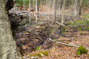
This 250-foot long, 3-foot high, beaver dam, a couple hundred yards east of East Street, Middleton, was started about five-years ago. The red maples above it have drowned. Mature yellow birches nearby are being girdled by the dam builders. – Judy Schneider photo
So, as always, beavers fascinate as they create rich new habitat called “beaver meadows” and destroy stands of favorite trees as they did twelve or so acres of Atlantic white cedars more than a decade ago around Pond Meadow Pond.
Let’s go further east downstream among the once red maple coppice shoots in the 1970s now grown and ready for another cutting as ambitious hardworking high schooler, Jonathan Webber, did to earn money during the fuel crisis back then. Someone told us he’d cut 100 cords of firewood there. Swamp red maples when cut send up lots of shoots from the base of their stumps. Some survive and after only 30 years or so become mature trees ready to be cut. One old Stream Teamer tells of cutting them in Salisbury as a lad.
We leave it up to you to visit the trails looping this valley’s wooded slopes and bottomland. Mountain folks would laugh at our using “valley” when the flanking hills to the north and south rise only 60 and 160 feet above its floor. See “Conservation Park” trail pages 71-74 in Middleton’s Trail book entitled Hiking for Health and History. You can get one for free at the Board of Health/Conservation Office. The 12 trails, their area’s natural and social history, and maps are also on line at the Middleton Stream Team web site.
We ended last week’s Water Closet essay about rail-trails singing a Roy Rogers and Dale Evans song “Happy Trails to You.”. We do so again.
____________________________________________________________________
WATER RESOURCE AND CONSERVATION INFORMATION
FOR MIDDLETON, BOXFORD AND TOPSFIELD
| Precipitation Data* for Month of: | Feb | March | April | May | |
| 30 Year Normal (1981 – 2010) Inches | 3.25 | 4.65 | 4.53 | 4.06 | |
| 2013 – 14 Central Watershed Actual | 4.34 | 4.32 | 2.86 | 0.2 as of 5/13** | |
Ipswich R. Flow Rate(S. Middleton USGS Gage) in Cubic Feet/ Second (CFS):
For May 13, 2014: Normal . . . 67 CFS Current Rate . . . 30 CFS
*Danvers Water Filtration Plant, Lake Street, Middleton is the source for actual precipitation data thru April. Normalsdata is from the National Climatic Data Center. –
**Updated May precipitation data is from MST gage..
THE WATER CLOSET is provided by the Middleton Stream Team: www.middletonstreamteam.org or <MSTMiddletonMA@gmail.com> or (978) 777-4584